Oronce Finé and the Heart-Shaped Map: Antarctica in the 16th Century?
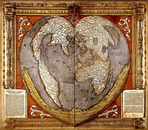
In the annals of cartographic history, few figures are as fascinating as Oronce Finé (also referred to as Oronteus Fineus, Oronteus Finaeuss, or Orontius Finaeus). A French mathematician, cartographer, editor, and book illustrator, Finé combined scientific rigor with artistic ingenuity, leaving behind a legacy that still sparks curiosity and debate among historians and researchers. His 1531 heart-shaped, or cordiform, map projection has been described as one of the earliest attempts to reconcile the known world with imaginative interpretations of unexplored regions—possibly even Antarctica.
Oronce Finé: Mathematician, Astronomer, and Cartographer
Oronce Finé was appointed Royal Mathematician and Astronomer in France, and his work bridged the fields of mathematics, astronomy, and geography. His 1534 map employed a cordiform projection, designed to represent the Earth’s curvature while maintaining proportional accuracy. This projection, shaped like a double human heart, became widely influential and was adopted by other notable cartographers, including Peter Apian and Gerardus Mercator.
The map’s dedicatory inscription reads:
“Oronce Finé of the Dauphiny to the Reader: We offer to you, Dear Reader, a representation of the entire world according to the views of modern Geographers and Hydrographers, preserving the proportion of the centre to both the Equator and the latitudes, laid out on a plane in the form of a double human heart…”
This statement reflects Finé’s desire to combine scientific accuracy with aesthetic representation, giving viewers both a functional map and a work of art.
Antarctica and Terra Australis
Finé’s 1531 map is notable for its depiction of the southern continent, Terra Australis, labeled as “recently discovered but not yet completely explored.” Supporters argue that the map places regions such as the Weddell and Ross Seas, Queen Maud Land, Wilkes Land, and Marie Byrd Land in approximately correct longitudes, a feat suggesting a remarkably advanced understanding of southern geography.
Some researchers suggest that Finé, like other early cartographers, may have drawn upon ancient sources or surviving maps from lost civilizations. This theory resonates with debates surrounding other controversial maps, such as the Buache Map of Antarctica and its ice-free version, which some claim depict the continent as it existed before being buried by ice.
Reconciling Myth and Discovery
Oronce Finé also integrated medieval legends, classical sources, and recent discoveries into his maps. On his world map, Nova Universi Orbis Descriptio (1531), he represented North America and Asia as a single landmass, while labeling South America as “America.” The southern lands included Tierra del Fuego, discovered by Ferdinand Magellan, and other speculative regions.
Finé’s cosmography was influenced by German mathematician Johannes Schöner, whose globes and maps informed the layout and geography of Finé’s mappemonde. Scholars like Lucien Gallois and Franz von Wieser have documented the striking similarities between Finé’s maps and Schöner’s globes, suggesting either direct collaboration or the use of Schöner’s earlier work as a template.
A Legacy of Innovation and Mystery
The heart-shaped map of Oronce Finé exemplifies the intersection of art, science, and imagination. While it is impossible to confirm whether Finé had accurate knowledge of Antarctica, the map reflects a deep understanding of geometric projection and astronomical principles, and demonstrates the desire of 16th-century thinkers to synthesize known and unknown information into a coherent worldview.
The map continues to inspire debate about the possibility that ancient or lost civilizations possessed sophisticated geographic knowledge. Its inclusion in discussions alongside the Buache Map of Antarctica highlights a pattern of intriguing, early cartographic depictions of southern continents, sparking curiosity about human understanding of the globe long before modern exploration.
Further Reading from Ancient360
For more insights into Antarctica and controversial ancient maps:
These articles explore theories that suggest early cartographers or civilizations may have mapped regions of our planet long before contemporary explorers, revealing fascinating connections between history, geography, and the enduring mysteries of the Earth.
References
______________________________________________________________________________________
- Cuochi, Diego “The Charter of Orontious Finaeus (Oronce Fine)” https://www.diegocuoghi.com/Piri_Reis/Finaeus.htm
- Frank J. Swetz (The Pennsylvania State University), Mathematical Treasure: Oronce Fine’s 1534 World Map https://www.maa.org/press/periodicals/convergence/mathematical-treasure-oronce-fine-s-1534-world-map
- Keith Fitzpatrick-Matthews, The Orontius Finaeus Map http://www.badarchaeology.com/old-maps/the-orontius-finaeus-map/
- Oronce Finé, Wikipedia, https://en.wikipedia.org/wiki/Oronce_Fin%C3%A9
- Library of Congress, control number: 2021668428 www.loc.gov/