
The Mystery of the Piri Reis Map: Ancient Knowledge or Coincidence?
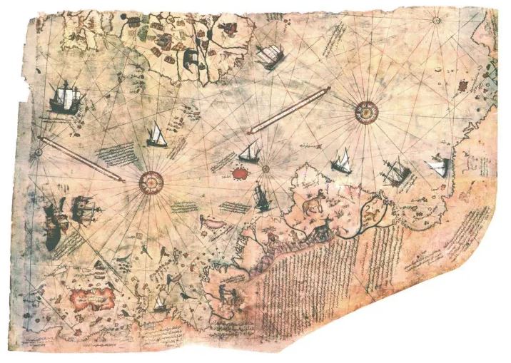
The Piri Reis Map, compiled in 1513 by Ottoman admiral and cartographer Ahmet Muhiddin Piri (Piri Reis), is one of the most puzzling documents of early cartography. Drawn on gazelle skin, the surviving fragment of this world map has fascinated historians, geographers, and mystery seekers for decades.
What makes the map extraordinary is not just its artistry but the information it appears to contain. It accurately portrays the coastlines of Europe, Africa, and South America, despite being created just two decades after Columbus’ first voyage. Even more intriguing is its alleged depiction of Antarctica, centuries before its official discovery in 1820.
A Navigator Ahead of His Time
Piri Reis was not merely a sailor—he was a collector of knowledge. His map was a compilation of around 20 earlier charts, including Portuguese maps, an Arab chart of India, and even one attributed to Christopher Columbus. This method allowed him to combine geographic data that seemed far ahead of the early 16th century.
When the fragment was rediscovered in 1929 at Istanbul’s Topkapı Palace, scholars were stunned. Was this map proof of a lost global knowledge system? Could it point to ancient civilizations capable of long-distance navigation, long before the Age of Discovery?
Does the Map Show Antarctica?
One of the most debated aspects is the southern section. The map depicts land at the tip of South America bending eastward. Some argue this is a distorted rendering of South America, while others claim it represents Antarctica—ice-free.
If true, this would suggest either an unknown ancient source of geographic knowledge or that explorers charted the continent before modern history records its discovery. However, geologists confirm that Antarctica has been under ice for at least 34 million years, making an ice-free depiction nearly impossible.
Unresolved Mysteries
The Piri Reis Map raises profound questions:
-
Was it merely a compilation of explorers’ reports?
-
Or does it hint at an older, forgotten civilization with advanced seafaring skills?
-
Could it even connect to the myth of lost antediluvian knowledge?
While most scholars agree the map is consistent with early 16th-century cartography, its anomalies ensure it remains a subject of endless fascination.
Conclusion
The Piri Reis Map is more than parchment and ink—it’s a portal into a past we still don’t fully understand. Whether the “Antarctica” it depicts is fact or fantasy, the map continues to fuel debates about ancient navigation, lost knowledge, and humanity’s forgotten history.
To continue exploring these mysteries, read related sources in our Ancient Maps Collection.
References
- Ponce de Leon the first European to find Florida
- Henry VIIIis King of England, married to Catherine of Aragon
- Vasco Nunez de Balboa spots the Pacific Ocean
- Niccolò Machiavelli writes The Prince
- Albrecht Durer, Raphael, Leonardo da Vinci, and Titian paintings
- Nicolaus Copernicus writings
- Michelangelo has just finished the Sistine Chapel ceiling
- Martin Waldseemüller is creating a map
- Martin Luther is teaching at the University of Wittenberg
- Piri Reis first world map published
- Ohio State University, Wind Rose, https://u.osu.edu/wagner.19/maps-to-know/1513-piri-reis/


3 Responses