The Piri Reis Mysteries: Map of Lost Knowledge?
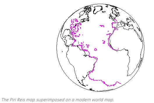
The Piri Reis Map, drawn in 1513 by Ottoman admiral and cartographer Ahmet Muhiddin Piri (Piri Reis), is one of history’s most intriguing cartographic relics. What survives today is only a fragment of a much larger map that originally depicted the known world. The existing portion shows the Atlantic Ocean, the western coasts of Europe and Africa, and the eastern coasts of the Americas.
Piri Reis claimed his chart was compiled from 20 older maps and 8 planispheres, including those by Christopher Columbus and early Portuguese explorers. Notes on the map even reference these sources, which Turkish scholars later transcribed and published in 1935.
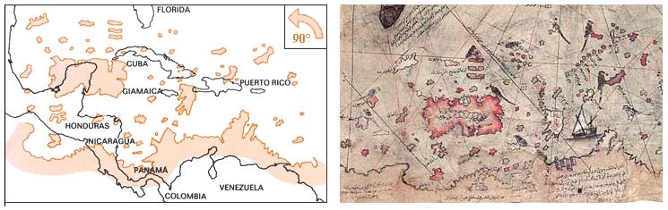
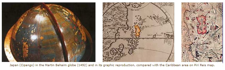
The Caribbean Puzzle
The Caribbean section of the Piri Reis Map appears distorted. It shows a large island aligned north-south, which does not correspond to Cuba but rather resembles Japan (Cipango) as it appeared in 15th-century maps, such as Martin Behaim’s 1492 planisphere. This suggests that Piri Reis relied heavily on earlier geographical theories that blurred the lines between Asia and the New World.
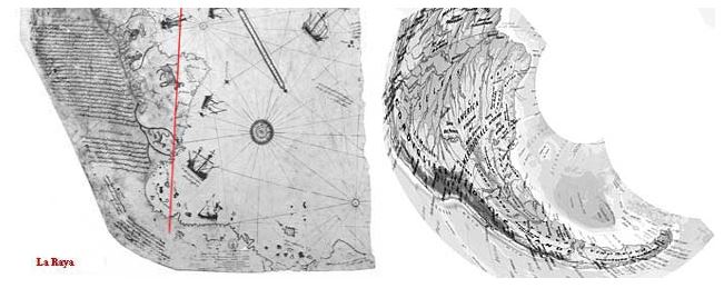
South America and the Antarctic Debate
The coast of Brazil is one of the most accurate portions of the map. Yet the depiction of land at its southern edge raises debate. Some claim this land is Antarctica, drawn centuries before its official discovery. But several problems arise:
-
A vast 1,200 miles of South American coastline is missing.
-
The supposed “Antarctica” protrudes from Brazil instead of lying far to the south.
-
The landmass may simply be an exaggerated extension of South America, not a separate continent.
Explorers like Amerigo Vespucci and Binot Paulmier de Gonneville had already reached southern latitudes by the early 1500s, but theories still persisted that South America was connected to Terra Australis Incognita—a mythical southern landmass.

Political Tools and Cartographic Style
Maps in the Age of Discovery were not only navigational aids but also political instruments. By bending coastlines or shifting territories, cartographers could favor their nation’s territorial claims under agreements like the Treaty of Tordesillas (1494).
The distortions on the Piri Reis Map may reflect these strategic choices, as well as the technical limits of the time—since accurate methods for calculating longitude would not exist until the 17th century.
.

Conclusion
The Piri Reis Mysteries lie at the intersection of cartography, exploration, and speculation. Whether the map shows a glimpse of Antarctica, or simply reflects the geographic theories and political ambitions of its time, it remains a captivating puzzle.
This enigmatic artifact challenges us to consider how knowledge was shared, adapted, and reimagined in an age when the world was still being discovered.
To explore more about mysterious charts and forgotten geographies, continue reading the related sources in our Ancient Maps Collection.