
The Zeno Map History
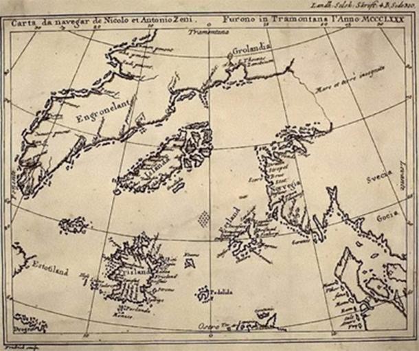
The Zeno Map History and the Problem of Forgotten Geography The Zeno Map history occupies a controversial yet fascinating position within the study of ancient maps. First published in 1558 by Nicolo Zeno the Younger, the map was claimed to be based on far older navigational charts and letters written by his ancestors, the Venetian […]
Piri Reis Map and the Impossible Coastlines

The Piri Reis Map and the Impossible Coastlines The Piri Reis map history occupies a unique and controversial position within the study of ancient maps, not because it is mysterious in isolation, but because it appears to preserve geographical knowledge that should not have been available to early sixteenth-century cartographers operating within the technological and […]
The Oronteus Finaeus Map: Antarctica Before Ice
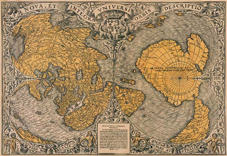
The Oronteus Finaeus Map: Antarctica Before Ice The Oronteus Finaeus map is one of the most unsettling artifacts in the history of cartography. Published in 1531, this Renaissance-era world map appears to depict Antarctica—three centuries before its official discovery—and not as the frozen wasteland we know today, but as a landmass with rivers, mountain ranges, […]
Ancient Maps of a Drowned World: Echoes of Lost Civilizations

Ancient Maps of a Drowned World: Echoes of Lost Civilizations The concept of an ancient maps drowned world challenges conventional history by suggesting that early cartographers preserved knowledge of coastlines and lands that no longer exist above sea level. Across multiple ancient maps—created centuries or even millennia apart—we find recurring depictions of submerged territories that […]
Piri Reis Map: Impossible Coastlines & Lost Knowledge

Piri Reis Map: Impossible Coastlines & Lost Knowledge The Piri Reis map history is one of the most controversial mysteries of cartography. Drawn in 1513 by the Ottoman admiral Piri Reis, this map contains coastlines that seem impossible for its time—suggesting knowledge that predates modern exploration and even hints at forgotten global cartographic traditions. Ancient […]
Ancient Maps: Knowledge Before Modern Cartography

Ancient Maps: Knowledge Before Modern Cartography Why Ancient Maps Still Disturb Modern Assumptions Ancient maps are often presented as crude, symbolic, or speculative attempts by early civilizations to understand their world. This assumption is comforting—but increasingly difficult to defend. When examined carefully, many ancient maps display levels of geographic accuracy, astronomical awareness, and mathematical sophistication […]
