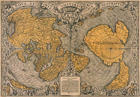
The Oronteus Finaeus Map: Antarctica Before Ice
The Oronteus Finaeus map is one of the most unsettling artifacts in the history of cartography. Published in 1531, this Renaissance-era world map appears to depict Antarctica—three centuries before its official discovery—and not as the frozen wasteland we know today, but as a landmass with rivers, mountain ranges, and ice-free coastlines. The implications are profound: either this map is wrong in extraordinary ways, or it preserves geographic knowledge inherited from a far older source.
For researchers exploring the possibility of lost civilizations and drowned worlds, the Oronteus Finaeus map occupies a central and unavoidable position.
Who Was Oronteus Finaeus?
Oronce Finé, known in Latin as Oronteus Finaeus, was not a fringe thinker or speculative mystic. He was one of the most respected mathematicians, astronomers, and cartographers of 16th-century France. Appointed as Royal Lecturer in Mathematics by King Francis I, Finaeus worked within the highest intellectual circles of his time.
His 1531 world map, titled Nova et integra universi orbis descriptio, was created during an era when cartography was rapidly improving but still constrained by limited exploration. Antarctica, according to conventional history, would not be sighted until 1820. Yet the Oronteus Finaeus map shows it clearly—and in surprising detail.
The Oronteus Finaeus Map and an Ice-Free Antarctica
The most controversial feature of the Oronteus Finaeus map is its southern continent. Unlike medieval “terra incognita” conjectures, this landmass closely matches the coastline of Antarctica when ice is removed.
Key details include:
-
Clearly defined coastlines
-
Large river systems flowing toward the sea
-
Mountain ranges inland
-
No permanent ice cap depicted
Modern radar imaging of Antarctica—using ice-penetrating technology—reveals ancient river beds and landforms beneath the ice that strongly resemble those drawn by Finaeus. This correspondence raises a difficult question: how could a 16th-century cartographer depict features that were only confirmed in the 20th century?
Rivers Beneath the Ice: Coincidence or Memory?
Perhaps the most striking element of the Oronteus Finaeus map is its river systems. Antarctica today has no surface rivers, yet beneath its ice sheets lie ancient drainage basins carved by flowing water.
Glaciologists estimate that parts of Antarctica were ice-free between 14,000 and 6,000 years ago, and possibly earlier during warmer interglacial periods. If the Oronteus Finaeus map reflects genuine geographic data, then its source material must originate from a time when Antarctica was not fully frozen—a time long before recorded history.
This aligns closely with themes explored in Ancient Maps of a Drowned World, where cartography appears to preserve environmental conditions that no longer exist. Could this be another example of ancient maps of a drowned world… Echoes of lost civilizations?
Ancient Sources and the Question of Inheritance
Oronteus Finaeus did not claim personal discovery of new lands. Like many Renaissance cartographers, he compiled his map from older sources—some known, others lost.
The question is not whether Finaeus explored Antarctica himself, but whether the Oronteus Finaeus map preserves fragments of much older geographic records.
Several possibilities emerge:
-
Pre-Ice Age Cartography
Maps originating from a civilization that existed before the last major glaciation. -
Survivor Knowledge
Geographic knowledge transmitted through cultures that survived catastrophic flooding or climate collapse. -
Lost Maritime Cultures
Advanced seafaring societies capable of global navigation far earlier than accepted timelines.
None of these explanations are comfortable for orthodox history, yet all remain plausible when the map’s details are examined objectively.
The Oronteus Finaeus Map and Earth Catastrophes
The depiction of Antarctica without ice invites discussion of catastrophic Earth changes. Rapid climate shifts, pole displacement theories, and large-scale flooding events have all been proposed as mechanisms capable of transforming global geography within short timeframes.
If such events occurred near the end of the last Ice Age, they would explain:
-
Sudden submergence of coastal civilizations
-
Loss of advanced cartographic knowledge
-
Fragmentary survival of maps copied centuries later
The Oronteus Finaeus map may not represent speculative imagination, but a snapshot of a world that existed before a global reset.
Skepticism and Conventional Explanations
Mainstream scholars often argue that the Oronteus Finaeus map is merely a distorted version of South America extended too far south. However, this explanation struggles to account for:
-
Accurate longitudinal proportions
-
Inland mountain placement
-
River orientations inconsistent with South America
The precision exceeds what would be expected from guesswork. While skepticism is healthy, dismissal without addressing these details risks overlooking genuine anomalies.
Why the Oronteus Finaeus Map Still Matters
The importance of the Oronteus Finaeus map lies not in proving a single theory, but in exposing gaps in our historical narrative. It joins a growing body of evidence—alongside the Piri Reis map and the Zeno map—that suggests ancient humanity may have possessed a deeper understanding of Earth’s geography than we currently acknowledge.
If maps can remember drowned continents, perhaps history itself has forgotten more than it remembers.
Conclusion
The Oronteus Finaeus map stands at the intersection of cartography, geology, and forgotten history. Whether viewed as a preserved relic of ancient knowledge or an extraordinary anomaly, it cannot be comfortably ignored.
In a world reshaped by ice, floods, and catastrophe, maps may be the last surviving witnesses. And if so, the Oronteus Finaeus map may be telling us that civilization’s story did not begin where we think it did—but long before the ice returned.
Additional Readings and Sources
-
Charles Hapgood – Maps of the Ancient Sea Kings – link
-
U.S. Geological Survey – Antarctic Subglacial Topography – link
-
British Antarctic Survey – Ice Sheet History
-
National Geographic – Early World Maps
-
Smithsonian Magazine – Renaissance Cartography
- Younger Dryas Abrupt Change – link