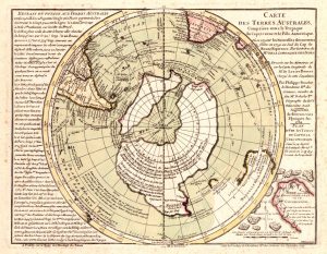
The Buache Map: Evidence of Ancient Knowledge of Antarctica?
Among the most intriguing enigmas of historical cartography is the Buache Map, an 18th-century chart that has sparked debates about whether ancient civilizations possessed advanced geographical knowledge long before the modern era. Some researchers claim that the map accurately depicts Antarctica before it was buried by ice, suggesting the possibility that early explorers or civilizations mapped the continent when it was still ice-free. Yet, these claims remain controversial, and the origins and intentions of the map are still debated among scholars.
Who Was Philippe Buache?
Philippe Buache de la Neuville (1700–1773) was a pioneering French geographer and cartographer. Born in Neuville-en-Pont, Buache studied at the Académie des Sciences and later joined the French Ministry of the Navy, where he specialized in mapping and cartography. By 1729, he became geographer to the king, eventually serving as a professor of geography.
Unlike many mapmakers of his time, Buache was more than a copyist. He analyzed voyages of discovery, gathered the latest geographical knowledge, and applied deductive reasoning to propose new features of the world. Among his notable successes was the early recognition of Alaska and the Bering Strait, decades before their official documentation. However, some of his theories, such as a central Antarctic Sea, were speculative, based on reports of icebergs observed by explorers like Bouvet in 1738.
The Controversy: Was Antarctica Known in Antiquity?
The central debate surrounding the Buache Map arises from claims that it accurately depicts the sub-glacial topography of Antarctica. This idea was popularized by Charles Hapgood in his 1966 book, Maps of the Ancient Sea Kings, which suggested that ancient civilizations may have mapped Antarctica before it was covered in ice.
Critics argue that this interpretation is flawed for several reasons:
-
Ice Coverage and Sea Levels: Modern maps of Antarctica’s sub-glacial topography exist only under millions of tons of ice. If the ice were removed, sea levels would rise, drastically altering coastlines.
-
Isostatic Uplift: The landmass would “bounce back” after the ice’s weight was lifted, raising some regions by up to 3,100 meters.
Additionally, the Buache Map depicts Antarctica as two separate landmasses, which may indicate speculation rather than direct observation. Some scholars suggest that Buache himself hypothesized the continent’s existence based on fragmentary reports and geographic deduction, rather than relying on an ancient source.
Ancient Maps and the Possibility of Advanced Knowledge
Despite these debates, the Buache Map is often discussed alongside other controversial maps, such as the Oronteus Finaeus Map and the Piri Reis Map. Proponents argue that these charts hint at a globally sophisticated cartography system in antiquity, capable of mapping continents with precision that rivals modern techniques.
Even if the maps were partly speculative, they suggest that early civilizations may have:
-
Understood the spherical nature of the Earth
-
Applied mathematical calculations and spherical trigonometry
-
Conceptualized global-scale geography long before modern cartography
The possibility that ancient humans—or a lost civilization—undertook projects to map the planet is both tantalizing and provocative. It challenges the conventional narrative that advanced geographic knowledge is exclusively modern.
A Legacy of Wonder and Mystery
The Buache Map stands as a testament to the curiosity and ingenuity of early cartographers. Whether it reflects true ancient exploration, deductive reasoning, or a combination of both, it continues to inspire debates about human knowledge and capability. For researchers and enthusiasts, the map serves as a reminder that the ancient world may have been far more sophisticated than traditionally imagined.
Further Reading from Ancient360
For a deeper understanding of ancient cartography and mysterious civilizations, explore these related articles:
-
Cart Ruts and Forgotten Civilizations: Traces of Cataclysmic History
-
The Cart Ruts of Syracuse: Ancient Tracks of Forgotten Civilizations
-
Cart Ruts in the USA: Ancient Tracks from Texas to California