
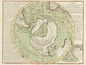
The Buache Map: Antarctica Before Ice? Exploring Ancient Knowledge
Few artifacts of cartographic history are as provocative and mysterious as the Buache Map, a chart drawn in Paris in 1737 by the French geographer Philippe Buache de la Neuville. The map’s depiction of Antarctica as two separate landmasses—a feature not scientifically confirmed until the 1958 Geophysical Year—has fueled speculation that ancient civilizations might have mapped the continent long before it was buried in ice.
Philippe Buache and the Southern Lands
Philippe Buache (1700–1773) was a pioneering figure in 18th-century cartography. Born in Neuville-en-Pont, France, he studied at the Académie des Sciences and rose to become geographer to the king. Buache was known for his analytical approach to geography, relying on the latest voyages of discovery while making deductions that were sometimes astonishingly accurate. For instance, he predicted the existence of Alaska and the Bering Strait decades before their official discovery.
The full title of the Buache Map is worth noting: Carte des Terres Australes comprises entre le Tropique du Capricorne et le Pôle Antarctique où se voyent les nouvelles découvertes faites en 1739 au Sud du Cap de Bonne Esperance, translating to “Map of the Southern Lands contained between the Tropic of Capricorn and the Antarctic Pole, showing discoveries made south of the Cape of Good Hope in 1739.” Interestingly, while the map is often cited as being created in 1737, the date on the map itself reads September 3, 1739.
Antarctica Ice-Free? The Mystery Deepens
The most compelling—and controversial—aspect of the Buache Map is its representation of Antarctica without ice, seemingly implying that the map was based on observations from an earlier, pre-ice age source. Advocates of this theory suggest that the map, along with others like the Piri Reis Map, Oronteus Finaeus Map, and Hadji Ahmed Map, points to a highly advanced civilization capable of global cartography thousands of years ago.
Some theorists link these maps to the Antediluvian period, a pre-flood era described in ancient texts like the Bible, when civilizations may have possessed knowledge and technologies that have since been lost. According to this perspective, these maps could represent the collective wisdom of societies that thrived before the great deluge, mapping the Earth with surprising accuracy.
Charles Hapgood and Ancient Global Cartography
Charles Hapgood’s influential work, Maps of the Ancient Sea Kings, argued that these early maps reflect a technological sophistication surpassing sixteenth-century Europe. Hapgood proposed that their creators not only charted the continents with remarkable precision but also recorded geographical features inaccessible to later explorers.
For instance, the Buache Map shows Alaska connected to Siberia via the Pleistocene land bridge, suggesting knowledge of ice age geography. Similarly, the map’s depiction of Antarctica as two distinct landmasses mirrors modern subglacial data, raising the provocative question: Could ancient humans—or lost civilizations—have possessed advanced surveying techniques far earlier than mainstream history acknowledges?
Skepticism and Scientific Debate
While intriguing, the claims surrounding the Buache Map remain controversial. Critics argue that Buache’s Antarctic depiction was likely hypothetical, based on deductions from reports of icebergs and southern ocean currents rather than on firsthand observation. Additionally, the challenges of reconstructing an ice-free Antarctica—considering sea level changes and isostatic rebound—make it impossible to confirm the map’s accuracy using modern methods.
Yet, whether speculative or based on ancient sources, the map continues to captivate researchers, highlighting the tantalizing possibility that human knowledge in antiquity may have been far more sophisticated than previously assumed.
A Legacy of Wonder
The Buache Map remains more than just a historical artifact; it is a window into humanity’s enduring curiosity about the world. Its enigmatic portrayal of Antarctica, alongside other ancient maps, invites questions about lost knowledge, global exploration, and the civilizations that may have preceded recorded history.
As ongoing research and modern mapping techniques continue to shed light on ancient cartography, the Buache Map stands as a symbol of the mystery and ingenuity of our ancestors, inspiring both scholars and enthusiasts to reconsider the limits of ancient human achievement.
Further Reading from Ancient360
For more insights into lost civilizations and mysterious maps, explore:
-
Cart Ruts and Forgotten Civilizations: Traces of Cataclysmic History
-
The Cart Ruts of Syracuse: Ancient Tracks of Forgotten Civilizations
-
Cart Ruts in the USA: Ancient Tracks from Texas to California


One Response