A World That No Longer Exists
The study of ice age navigation routes introduces a fundamentally different geographical framework for understanding early human movement, as it requires acknowledging that the landscapes known today represent only a fraction of those that existed during the last glacial maximum, when sea levels were more than 100 meters lower and vast continental shelves were exposed as habitable land. In this context, coastlines extended far beyond their present limits, forming interconnected regions that allowed for migration, trade, and exploration across areas that are now submerged beneath modern oceans (Ancient Ocan Navigation Finding Land Without Tools – link).
This perspective is supported by extensive geological and paleoclimatic research, which has reconstructed ancient shorelines and demonstrated that entire ecosystems once thrived in areas currently underwater, suggesting that a significant portion of early human activity may have occurred in regions that are now inaccessible to traditional archaeology (Ancient Mapping the Sky – link). As a result, the apparent gaps in the archaeological record may not reflect an absence of activity, but rather the loss of evidence due to post-glacial sea level rise, raising the question of how many navigation systems, routes, and coastal cultures have effectively disappeared from historical visibility (Navigation Systems Before Maps – link).
Sea Level Rise and the Disappearance of Routes
At the end of the last Ice Age, global temperatures increased rapidly, triggering the melting of massive ice sheets and causing sea levels to rise by approximately 120 meters over several millennia, fundamentally reshaping the surface of the planet and submerging vast low-lying regions that had previously served as migration corridors (Ancient Maps and Star Charts Lost Knowledge Traditions – link). Within the framework of ice age navigation routes, this transformation represents not only an environmental shift but also a large-scale erasure of geographical knowledge, as routes that were once stable and well understood became fragmented or entirely inaccessible (Cities Beneath Ice Age Seas – link).
This process was not instantaneous but occurred in pulses, sometimes associated with rapid meltwater events that could have dramatically altered coastlines within relatively short periods, forcing human populations to adapt, relocate, or abandon established pathways (Ancient Navigation Technology Evidence of Lost Survey Methods – link). The cumulative effect of these changes suggests that the navigational knowledge of Ice Age populations may have been highly dynamic, evolving in response to shifting environments while simultaneously preserving memory of landscapes that no longer existed (Lost Knowledge of the Ice Age – link).
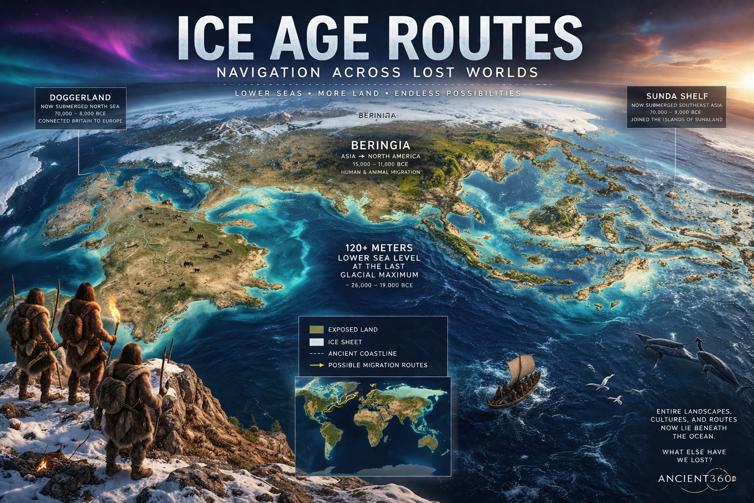
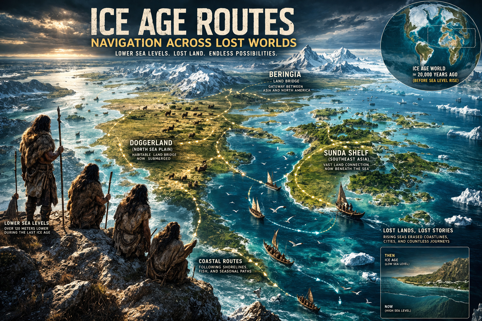
Doggerland: The Lost Heart of Northern Europe
One of the most well-documented examples of ice age navigation routes is Doggerland, a now-submerged region in the North Sea that once connected Great Britain to mainland Europe, forming a vast and resource-rich landscape inhabited by both animals and human populations. Archaeological and geological studies have revealed that Doggerland was not a marginal environment but a thriving ecosystem with rivers, forests, and wetlands, providing ample resources for sustained habitation (Lost Worlds Before the Flood – link).
As sea levels rose, Doggerland gradually transformed into a series of islands before being fully submerged, effectively severing the land connection between Britain and the continent and altering migration and trade patterns in the region. For the populations living there, this would have required not only physical relocation but also the development of new navigation strategies, potentially including early forms of maritime navigation to maintain connections across increasingly fragmented territories (Mapping the Skies Before Civilizations – link).
Beringia: Gateway Between Continents
Another critical component of ice age navigation routes is Beringia, the land bridge that once connected Siberia and North America, allowing for the migration of humans and animals between the two continents (Science before the Younger Dryas – link). Unlike a narrow corridor, Beringia was a vast region that supported diverse ecosystems and sustained human populations over extended periods, functioning as both a passageway and a habitat.
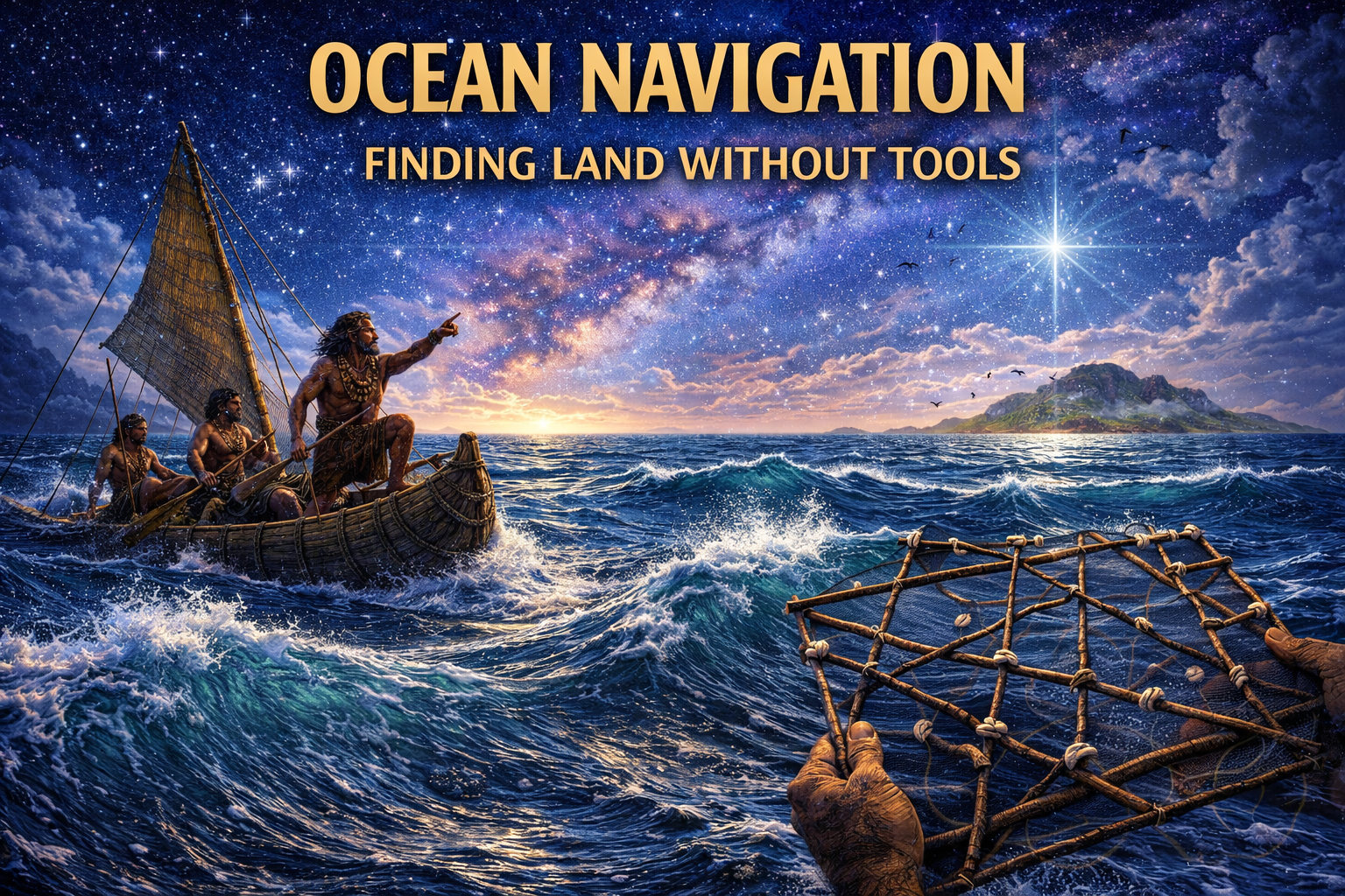
The existence of Beringia has been central to models of early human migration into the Americas, yet its role as a navigational landscape is often underexplored, particularly in terms of how populations may have moved within and beyond it. Coastal migration theories suggest that early humans may have followed shorelines, using both terrestrial and maritime navigation strategies to explore new territories, implying that ice age navigation routes were not limited to land-based movement but may have incorporated complex interactions between land and sea (Lost Knowledge Before Written History – link).
The Sunda Shelf: A Submerged Southeast Asia
In Southeast Asia, the Sunda Shelf represents another major example of ice age navigation routes, where lower sea levels exposed a vast landmass connecting present-day islands such as Indonesia, Malaysia, and Borneo into a continuous region (Ancient Maps of a Drowned World Echoes of Lost Civilizations – link). This expanded landscape would have facilitated movement across what are now separate islands, allowing for cultural and genetic exchange across a much broader area than is currently visible (Ancient Knowledge Before Modern Cartography – link).
As rising seas fragmented this landmass into the archipelagos known today, populations would have been forced to adapt to increasingly maritime environments, potentially accelerating the development of navigation skills that later became highly refined in regions such as Polynesia. This transition highlights the possibility that some of the world’s most advanced traditional navigation systems may have roots in earlier adaptations to changing Ice Age landscapes.
Coastal Migration and the Missing Archaeology
A growing body of research supports the idea that early human migration often followed coastal routes, which would have provided access to abundant marine resources and relatively stable climates, yet within the context of Ice Age navigation routes, this creates a significant challenge for archaeology, as many of these coastal sites are now submerged beneath modern seas. This has led to what some researchers describe as a “missing coastline problem,” where critical evidence of early human activity may be inaccessible using conventional excavation methods. If vast stretches of early human settlement now lie underwater, it raises the possibility that entire phases of migration remain undocumented. Discoveries linked to submerged regions like Doggerland suggest that these lost landscapes were once central to human life rather than peripheral zones. This invites the question of whether current historical models are built on only a fraction of the original evidence (Easter Island Moai Guardians of Stone – link).
Advances in underwater archaeology, including sonar mapping and remote sensing, are beginning to address this gap, revealing submerged landscapes and potential sites of interest, although the field remains in its early stages. The implications are significant, as they suggest that current models of human migration and development may be based on incomplete data, with key pieces of the puzzle still hidden beneath the ocean. Sites such as Pavlopetri demonstrate that complex settlements can survive beneath the sea, largely undisturbed for millennia. This raises the possibility that far older and potentially more significant sites remain undiscovered. As exploration continues, these hidden environments may reshape our understanding of early human capabilities and movement.
Navigation Across Changing Worlds
Within the framework of Ice Age navigation routes, navigation must be understood as a dynamic process that adapted to continuously changing environments, rather than a fixed system operating within stable geographical boundaries. As coastlines shifted and landscapes transformed, navigators would have needed to update their mental maps, incorporate new landmarks, and develop strategies for navigating increasingly complex and fragmented terrains. This suggests that navigation was an evolving system, shaped by long-term environmental instability rather than short-term conditions alone. If landscapes could disappear within generations, navigators may have relied on more abstract and transferable knowledge systems. This raises the possibility that some navigational principles were designed to persist even as physical geography changed.
This adaptive capacity suggests a level of cognitive flexibility and environmental awareness that aligns with the broader patterns observed in prehistoric navigation systems, reinforcing the idea that early humans were not passive occupants of their environment but active participants in its interpretation and transformation. The ability to maintain continuity of movement and knowledge across such changes raises important questions about the mechanisms of knowledge transmission and the resilience of cultural systems. How knowledge was preserved through periods of disruption remains an open and compelling question. Oral traditions and repeated journeys may have played a critical role in maintaining continuity across generations. Yet major environmental shifts could have interrupted these systems, leaving only partial traces behind.
Lost Landscapes and Cultural Memory
An intriguing aspect of Ice Age navigation routes is the possibility that memories of lost landscapes may have been preserved in cultural traditions, myths, and oral histories, even after the physical environments themselves had disappeared. While such connections must be approached with caution to avoid overinterpretation, the widespread presence of flood narratives and references to submerged lands across different cultures suggests that significant environmental changes were experienced and remembered by early societies. Accounts such as those found in the Epic of Gilgamesh continue to prompt questions about how such stories originated. Could these narratives reflect distant memories of real events passed down over generations? If so, they may offer indirect insight into experiences that left little physical evidence (Lost Ancient Science From Sky to Stone – link).
Rather than viewing these narratives as purely symbolic, it may be useful to consider them as potential reflections of real events, encoded in forms that could be transmitted across generations without written records. This perspective aligns with the broader Ancient360 approach, which emphasizes the importance of integrating multiple lines of evidence—archaeological, geological, and cultural—to build a more comprehensive understanding of the past. When considered alongside evidence of rising sea levels at the end of the last Ice Age, these stories take on new significance. They may represent cultural attempts to preserve knowledge of dramatic environmental change. In this way, memory and myth become important complements to the physical archaeological record.
Conclusion: The Hidden Geography of Human History
The exploration of Ice Age navigation routes reveals a hidden layer of human history shaped not only by movement across space, but by mastery of the sky, sea, and memory itself. From star paths and celestial tracking to the reading of waves, winds, and currents, and from solar and lunar cycles to subtle environmental signals like birds and clouds, each system points toward a level of sophistication that challenges conventional assumptions about early human capability (Submerged Caribbean City 6,000 Years Underwater Discovery – link). When considered alongside coastal migration patterns, submerged landscapes, and the “missing coastline problem,” a striking possibility emerges: much of humanity’s earliest innovation may have taken place in regions now lost beneath the sea (Cosmic Code Geometry of Ancient Structures – link).
Across these interconnected systems—navigation without instruments, dynamic adaptation to shifting worlds, and the preservation of knowledge through storytelling—we see not isolated skills, but a coherent intellectual framework. Sites such as Göbekli Tepe, Nabta Playa, and submerged landscapes like Doggerland and Pavlopetri hint that fragments of this knowledge have survived—but only barely. If these are the remnants, what scale of understanding might have existed in the vast coastal regions now erased by post-Ice Age sea-level rise? And if oral traditions, myths, and cultural memory preserved echoes of these worlds, are we only beginning to recognize their true significance?
Rather than a simple, linear progression from primitive to advanced, human history may be better understood as cyclical, adaptive, and at times interrupted—shaped by environmental upheaval as much as by innovation (Forgotten Engineers Builders Beyond Time – article1 and article2). The integration of celestial navigation, environmental awareness, cognitive mapping, and long-distance movement suggests that early humans were capable of building resilient and complex systems of knowledge, some of which may have been lost in episodes of rapid climatic change. This raises a profound possibility: that entire chapters of human development—perhaps even sophisticated coastal civilizations—have disappeared, leaving behind only scattered clues across archaeology, geology, and tradition.
What emerges is not just a reinterpretation of navigation, but a reframing of human history itself. The oceans may not simply divide continents; they may conceal the foundations of early human achievement. And as technology begins to uncover submerged landscapes and forgotten sites, we are faced with an unsettling and exciting question: are we rediscovering the edges of a story we once knew, or uncovering evidence of a past far more advanced—and far more fragile—than we have ever imagined?
References & Further Reading
Nature — Sea Level Rise After the Last Glacial Maximum
National Geographic — Doggerland Discoveries
Smithsonian — Bering Land Bridge Studies
Journal of Archaeological Science — Coastal Migration Theory
NOAA — Paleoclimatology and Ocean Changes
Ancient360 — Ancient Maps & Navigation Series – link
Journal of Anthropological Archaeology – link
Ancient360 — Submerged Civilizations & Ancient Maps – link