The Piri Reis Map Sources: Tracing the Origins of a Cartographic Mystery
On October 9, 1929, while cataloging non-Arabic manuscripts for the Turkish Ministry of Education, Gustav A. Deissmann stumbled upon a bundle of forgotten maps in Istanbul’s Topkapı Palace. Among them was a fragment of a 1513 world map created by Hacı Ahmed Muhiddin Piri—better known as Piri Reis. This discovery sent shockwaves through the academic world, as the map appeared to contain knowledge far beyond its time.
Piri Reis was no ordinary cartographer. A lifelong sailor in the Ottoman Navy, he rose to the rank of Admiral and eventually commanded the Ottoman fleet in the Indian Ocean and Egypt. He was also a scholar of navigation and geography, compiling maps and charts into his celebrated Kitāb-ı Baḥrīye (Book of the Sea)—a monumental work of 434 pages with 290 maps detailing islands, ports, and coasts of the Mediterranean. A revised version of this work was later presented to Sultan Suleiman I in 1525.
A Fragment of a Larger Masterpiece
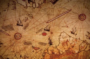
The Piri Reis map fragment is believed to be only about one-third of the original chart, which was drawn on gazelle skin. The surviving portion measures roughly 90 x 63 cm (35 x 24 in), although the exact size varies due to a damaged corner. The map is drawn in the style of a portolan chart, featuring four wind roses with radiating rhumb lines—classic navigational tools of the time.
Geographically, this surviving section depicts Western Africa, the Atlantic Ocean, South America, parts of North America, and the Caribbean Sea. One of its most striking features is that South America is plotted longitudinally correct in relation to Africa—something no other known 16th-century map achieved. Yet, the coastlines of North America and southern South America are far less accurate, reflecting the uncertainties of early exploration.
Political Tensions and Odd Shapes
In 1513, maps of the Old World were relatively accurate, but maps of the New World were still in flux. Each returning voyage brought new, often conflicting, details. European powers jealously guarded their cartographic knowledge, as maps were strategic assets.
Curiously, the Piri Reis map shows South America with an exaggerated eastward curve. Cape Horn had not yet been discovered, leaving the continent incomplete. Some suggest this distortion may represent an early depiction of Antarctica, while others argue it may have been a political maneuver—a way to grant the Portuguese more territory than what was officially allowed under the Treaty of Tordesillas (1494), which divided the New World between Spain and Portugal.
The Lost Sources
What makes the Piri Reis map especially intriguing are the handwritten notes scattered across its surface. In these, Piri Reis openly describes his sources:
-
Eight maps from Ptolemy’s tradition
-
An Arabic map of India
-
Four new Portuguese maps from the Indian Ocean
-
Christopher Columbus’ map of the Western lands
This last point is perhaps the most tantalizing. Piri Reis claimed he had access to a lost map drawn by Columbus during his voyages in the Caribbean. Yet no trace of this legendary chart has ever been found, despite extensive searches since 1929. The possibility that fragments of Columbus’ own work survived in the Piri Reis map fuels both historical debate and alternative theories.
Mystery in the Topkapı Palace
Presented to Sultan Selim I in 1517, the map eventually found its way into the archives of the Topkapı Palace Library, where it remains today. It is not on public display, and the full details of its origins remain elusive. Scholars debate whether its anomalies are errors of projection, political distortions, or hints of older, now-lost maps drawn by advanced civilizations.
Whatever the truth, the Piri Reis map stands as one of the most mysterious cartographic relics of the early modern world—bridging myth, politics, and the enduring quest to understand how much our ancestors really knew about the globe.
Related Reading on Ancient Maps:
-
The Piri Reis Mysteries: Fact, Fiction, and Forgotten Cartography
-
Oronce Finé’s Cordiform Map: Heart-Shaped World or Hidden Knowledge?
Or continue exploring all Ancient Maps in our archive: https://ancient360.eu/category/ancient-maps/
References
_______________________________________________________________________________________
- Ponce de Leon first European to discover Florida
- Henry VIII King of England married to Catherine of Aragon
- Vasco Nunez de Balboa spots the Pacific Ocean
- Niccolò Machiavelli writes The Prince
- Albrecht Durer, Raphael, Leonardo da Vinci, and Titian paintings
- Nicolaus Copernicus writings
- Michelangelo finished the Sistine Chapel ceiling
- Martin Waldseemüller creating a map
- Martin Luther teaching at the University of Wittenberg
- Piri Reis first world map published
- Ohio State University, Wind Rose, https://u.osu.edu/wagner.19/maps-to-know/1513-piri-reis/