A Map That Continues to Puzzle Scholars and Enthusiasts Alike
On October 9, 1929, while cataloguing neglected manuscripts in Istanbul’s Topkapı Palace, German theologian Gustav A. Deissmann unearthed a bundle of parchment charts that had lain forgotten for centuries. Among them was a curious fragment drawn in 1513 by Hacı Ahmed Muhiddin Piri — better known as Piri Reis — depicting coastlines with an unexpected level of detail for its time. This discovery caused widespread interest because the chart included stretches of the Americas drawn with surprising proportional relationships and marginal notes claiming sources that otherwise no longer exist.
Piri Reis was not a typical mapmaker: he was a sailor, military commander, admiral, and geographer whose career bridged practical naval experience, scholarly cartographic skill, and engagement with a wide range of geographic knowledge traditions. This combination makes his surviving chart — and its tenuous claims about obscure sources such as lost maps of Christopher Columbus or older Mediterranean charts — one of the most significant cartographic relics of the early modern world.
This article explores the sources of the Piri Reis map, its historical context, its composition, the credibility of the claims embedded in it, and what it can realistically tell us about the transmission of geographic knowledge in the age of exploration. It also looks at why some have speculated about deeper, even forgotten sources — and why mainstream history stops short of those more extraordinary claims.
Piri Reis — The Man Behind the Map
Piri Reis was born in Gallipoli in the mid‑1460s, into a seafaring family whose members were deeply involved in naval affairs. His uncle, Kemal Re’is, was a noted corsair whose activities later brought him into official service with the Ottoman navy. Piri’s early life was shaped by these experiences; he joined his uncle on voyages in the Mediterranean and beyond, learning practical navigation firsthand.
Over time Piri advanced from corsair to naval officer and eventually Admiral (Reis) in the Ottoman fleet. His career took him across the Mediterranean and into the Indian Ocean and Red Sea, where he engaged both in military action and the gathering of maritime geographic knowledge.
Far from being a purely practical sailor, Piri was also a scholar of navigation. His masterwork, the Kitāb‑ı Baḥrīye (Book of the Sea), was not just a navigational guide but an encyclopaedia of coastal geography, winds, tides, currents, ports, islands, and practical nautical wisdom compiled into 434 pages with nearly 300 coastal charts. A revised version of this work was presented to Sultan Suleiman I in 1525, indicating the scholarly stature Piri had achieved within the Ottoman intellectual milieu.
Yet it is his 1513 world map — a fragment of which survives — that continues to captivate researchers because it combines geographic data from a variety of sources, some of which may be lost to history.
A Fragment of a Larger Masterpiece
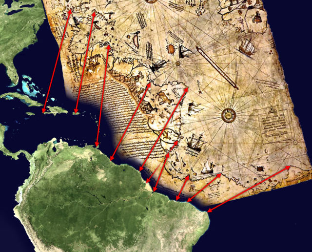
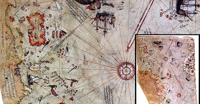
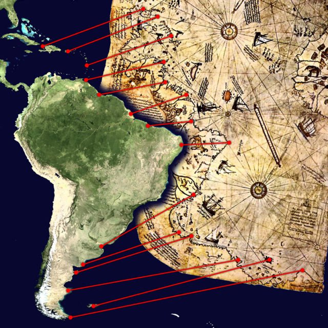
The surviving piece of the Piri Reis map covers a portion of the world drawn on gazelle‑skin parchment, in the style of a portolan chart — a navigational map using compass roses and rhumb lines instead of latitude and longitude grids. Only about one‑third of the original chart survives, measuring roughly 90 × 63 cm (35 × 24 in), missing its eastern and other peripheral sections.
The fragment shows:
-
Western Europe and North Africa with notable accuracy,
-
Western and South America’s Atlantic coastline with impressive proportional relationship to Africa (unusual for its era),
-
Parts of the Caribbean and other Atlantic islands,
-
Marginal notes in Ottoman Turkish describing sources and geographic features.
Notably, the map predates accurate European depictions of the Americas by over a decade and imports geographic information that — in some cases — was not available in the detailed form found elsewhere until many decades later. Although some features (e.g., the Caribbean) are distorted or reflect misconceptions such as Columbus’s misidentification of islands as part of Asia, other parts show remarkable competency for the era.
How Was the Map Used? Navigation, Knowledge, and Empire
The Piri Reis map was a practical navigational chart, not an abstract projection for scholarly speculation. As a portolan, it was designed for usage at sea — incorporating compass roses and windrose networks to guide sailors across the Mediterranean and Atlantic. Portolan charts were the standard navigational tools of Mediterranean mariners and were widely employed by sailors relying on dead reckoning and compass bearings to estimate positions relative to known coastal landmarks.
After its creation, Piri presented the map to Sultan Selim I after the Ottoman conquest of Egypt in 1517. It is unknown whether Selim used the map operationally; the document subsequently vanished from history until its rediscovery in 1929.
As a navigational aid, the map would have served to consolidate geographic knowledge at a time when European maritime powers were expanding their reach across the Atlantic, around Africa, and into the Indian Ocean. This makes the chart not merely a depiction of distant lands but a statement about knowledge networks — where information was gathered, who had access to it, and how it was repurposed within the Ottoman sphere.
What Did Piri Reis Claim as His Sources?
What makes the Piri Reis map particularly fascinating is the handwritten source notes that Piri himself left in the margins of the chart. These notes openly list several specific sources that he claimed to have used to compile the map — a rare level of transparency for a 16th‑century cartographer.
Among the sources he cited were:
-
Eight maps from the Ptolemaic tradition: referring to maps passed down through medieval and Islamic geographers deriving from Claudius Ptolemy’s influential second‑century geographic system.
-
An Arabic map of India: reflecting the extensive geographic knowledge circulating in Islamic trade and navigation traditions, particularly in the Indian Ocean.
-
Four Portuguese charts: likely drawn from recently compiled Portuguese navigational maps of Africa, India, and beyond — including explorations around the Cape of Good Hope.
-
A map attributed to Christopher Columbus: of the Western lands. Piri asserts that he had access to a chart drawn by Columbus himself, now lost to history.
These marginal annotations do not simply reference broad traditions but named individual sources — which makes them some of the few documented traces of now‑lost early mapping materials. Scholars have treated these sources seriously, even as they debate how accurately later maps reflected first‑hand observations.
Did Piri Really Use Columbus’s Map?
Among the sources he mentioned, the most striking — and controversial — claim is that he used a map drawn by Christopher Columbus of the coasts and islands of the Western lands. If true, the Piri Reis map would be the only surviving witness to a chart made by Columbus himself.
Scholars like Paul Kahle, who studied the Topkapı map in the early 20th century, suggested Piri’s claim is justifiable historically, pointing to context in which Ottoman sailors captured Spanish ships in 1501 during a naval battle, possibly obtaining navigational charts that had been with Columbus or his pilots.
However, there is no surviving Columbus map matching this description in any European or American archive. The original Columbus map remains lost, and all references to it survive only through Piri’s notes and later cartographic traditions. That makes definitive claims about its existence hypothetical — though not implausible — and open to interpretation by historians.
Portolan Charts, Compilation, and the Puzzle of Accuracy
The Piri Reis fragment is a compilation rather than an original observational map. A portolan chart relies on existing coastal knowledge and relative bearings rather than latitude/longitude calculations. The fact that the surviving map achieves a relatively accurate depiction of Africa’s western coast and the eastern edge of South America — something most early 16th‑century maps failed to do — demonstrates both the quality of its sources and Piri’s skill in synthesising them.
At the same time, the map contains distortions — particularly in the Caribbean region and portions of the North American coast. These reflect imperfect transmission of earlier knowledge and the challenges of reconciling disparate source materials with differing projections and inaccuracies.
This combination of accuracy and distortion is key to understanding the map realistically: its value lies not exclusively in what it reveals but in how it integrates many pieces of geographic knowledge available at that moment in history.
Was the Map Composed of Other Pieces?
Scholars agree the surviving fragment is part of a larger original map, likely drawn on multiple panels and assembled from diverse source charts. The marginal notes suggest Piri was working from more than twenty maps, meaning the original chart was likely comprehensive in scope — covering the known world from European, African, and American coastlines to perhaps Indian Ocean regions.
The loss of the remainder means we now lack the complete picture of Piri’s synthesis, but the surviving piece offers a cross‑section of geographic tradition — a mosaic of inherited cartographic memory updated for the age of exploration.
Political Context, Enemy Maps, and Strategic Cartography
Maps in the early 1500s were not just academic tools; they were state secrets. European powers jealously guarded their charts because geographic knowledge was tied to naval and commercial advantage. Iberian maps of the New World were highly guarded, and information captured from enemy vessels could be crucial intelligence.
The Seyyid Piri Reis map reflects this dynamic: Ottoman fleets contended with Portuguese, Spanish, Venetian, and other rival navies, and map acquisition could occur through capture, trade, or diplomatic exchange. The presence of Portuguese sources and a reference to Columbus’s chart highlights the multicultural and geopolitical complexity of early global cartography.
Alternative Interpretations and the Question of Lost Knowledge
Some fringe interpretations have claimed the Piri Reis map contains evidence of advanced ancient civilizations or pre‑ice‑age Antarctic knowledge. These theories typically point to the map’s southern extremities and claim it depicts a coastline not yet officially charted by Europeans until the 19th century.
However, mainstream scholarship does not support these interpretations. The shape interpreted as Antarctic by some is more plausibly understood as a distorted portrayal of South America’s southern tip, influenced by source maps and projection limitations of the time. There is no credible geological or archaeological evidence that Antarctica was mapped before European exploration reached it.
What is credible is that the map shows the state of geographic knowledge circa 1513 — a blend of firsthand European discoveries, Islamic navigational charts, Mediterranean portolan tradition, and Piri’s own eclectic synthesis. It therefore offers a rare glimpse into how knowledge was transmitted, amalgamated, and repurposed in an era before systematic global surveying.
Legacy, Rediscovery, and Modern Debate
After Piri gifted the map to Sultan Selim I in 1517, it sank into obscurity until its rediscovery in 1929 within the Topkapı Palace library. The initial announcement generated significant international interest, partly because it was mistakenly reported as a map of Columbus himself and partly because it seemed to portray lands Europeans had not yet charted in detail.
Since then, scholars have rigorously analysed the map’s content, sources, and marginal notes — concluding that while some features remain ambiguous, the most plausible explanation is a confluence of inherited cartographic knowledge and contemporary exploration accounts. It has become an indispensable reference for historians of cartography, maritime history, and early modern geography.
Conclusion — Between History and Mystery
The Piri Reis map of 1513 remains one of the most remarkable artefacts in cartographic history. It is not a simple echo of a lost civilization, nor definitive proof of pre‑modern global surveying. Instead, it is the product of a complex network of transmitted knowledge — drawn from Portuguese, Arabic, Ptolemaic, and possibly Columbus’s own charts — assembled by a seasoned Ottoman admiral with access to multifaceted geographic traditions.
Rather than seeing the map as a mystery that defies explanation, a more grounded appreciation recognizes it as evidence of how humanity’s geographic understanding evolved: compiled, debated, lost and rediscovered, reflecting both the limitations and the ingenuity of its time.
Related Reading and References
-
The Piri Reis Map and the Impossible Coastlines (link)
- Piri Reis Book of Navitation (link)
-
UNESCO — Piri Reis World Map (link
-
Evidence of Prehistoric Global Exploration? (link)
-
Charles H. Hapgood — Maps of the Ancient Sea Kings (link)
-
1001 Inventions — Summary of Piri Reis map sources (link)
- Ponce De Leon – First European to Discover Florida (link)
-
Piri Reis First World Map (link)
- Ohio State University Piri Reis Map (link)