
Buache Map: Ancient Knowledge of Antarctica?

The Buache Map: Evidence of Ancient Knowledge of Antarctica? Among the most intriguing enigmas of historical cartography is the Buache Map, an 18th-century chart that has sparked debates about whether ancient civilizations possessed advanced geographical knowledge long before the modern era. Some researchers claim that the map accurately depicts Antarctica before it was buried by […]
The Piri Reis Map Controversy

The Piri Reis Map Controversy What is the Piri Reis Map? The Piri Reis map has stirred commotion since the moment of its discovery. Compiled in 1513, it is one of the oldest post-Columbian world maps in existence. Drawn on gazelle skin by Ottoman admiral and cartographer Piri Reis, the map blends remarkable detail with […]
The Piri Reis Map Sources
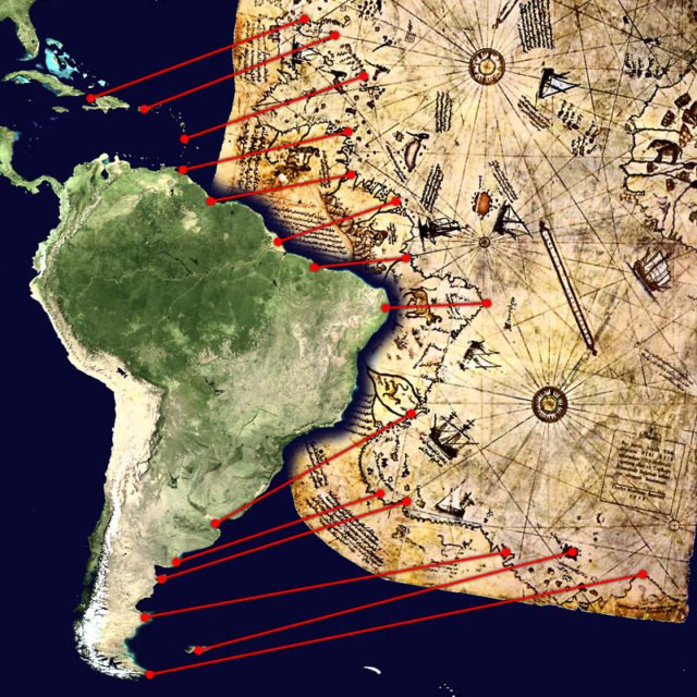
A Map That Continues to Puzzle Scholars and Enthusiasts Alike On October 9, 1929, while cataloguing neglected manuscripts in Istanbul’s Topkapı Palace, German theologian Gustav A. Deissmann unearthed a bundle of parchment charts that had lain forgotten for centuries. Among them was a curious fragment drawn in 1513 by Hacı Ahmed Muhiddin Piri — better known as Piri Reis — depicting coastlines […]
The Piri Reis Map Mysteries

The Piri Reis Mysteries: Map of Lost Knowledge? The Piri Reis Map, drawn in 1513 by Ottoman admiral and cartographer Ahmet Muhiddin Piri (Piri Reis), is one of history’s most intriguing cartographic relics. What survives today is only a fragment of a much larger map that originally depicted the known world. The existing portion shows […]