
The Oronteus Finaeus Map: Antarctica Before Ice
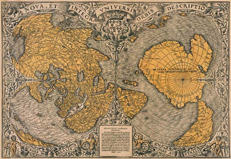
The Oronteus Finaeus Map: Antarctica Before Ice The Oronteus Finaeus map is one of the most unsettling artifacts in the history of cartography. Published in 1531, this Renaissance-era world map appears to depict Antarctica—three centuries before its official discovery—and not as the frozen wasteland we know today, but as a landmass with rivers, mountain ranges, […]
Ancient Maps of a Drowned World: Echoes of Lost Civilizations

Ancient Maps of a Drowned World: Echoes of Lost Civilizations The concept of an ancient maps drowned world challenges conventional history by suggesting that early cartographers preserved knowledge of coastlines and lands that no longer exist above sea level. Across multiple ancient maps—created centuries or even millennia apart—we find recurring depictions of submerged territories that […]
Buache Map: Ancient Knowledge of Antarctica?

The Buache Map: Evidence of Ancient Knowledge of Antarctica? Among the most intriguing enigmas of historical cartography is the Buache Map, an 18th-century chart that has sparked debates about whether ancient civilizations possessed advanced geographical knowledge long before the modern era. Some researchers claim that the map accurately depicts Antarctica before it was buried by […]
Buache Map: Ice-Free Antarctica or Ancient Cartography?

The Buache Map: Antarctica Before Ice? Exploring Ancient Knowledge Few artifacts of cartographic history are as provocative and mysterious as the Buache Map, a chart drawn in Paris in 1737 by the French geographer Philippe Buache de la Neuville. The map’s depiction of Antarctica as two separate landmasses—a feature not scientifically confirmed until the 1958 […]
The Oronteus Finaeus Controversy

The Orontius Finaeus Map: Did Ancient Cartographers Know Antarctica? Oronce Finé — also known as Oronteus Fineus or Orontius Finaeus — was a French mathematician, cartographer, and Royal Astronomer who left behind some of the most enigmatic maps of the Renaissance. Among them, his 1531 heart-shaped projection map has fueled centuries of debate. Could Finé’s […]
