Phantom Islands in the North Atlantic
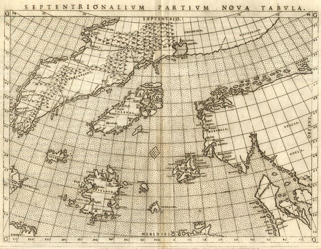
The Zeno Map, first published in Venice in 1558, is one of the most enigmatic cartographic artifacts of the Renaissance. Allegedly based on the voyages of two 14th-century Venetian brothers, Nicolò and Antonio Zeno, it depicts a cluster of islands—Frisland, Icaria, Estotiland, and Drogeo—lying between Iceland, Greenland, and the supposed western lands of the North Atlantic. These islands have never been verified by modern geography, and for centuries the map has fueled debates over the authenticity of its sources, the accuracy of its geographic details, and the motivations behind its publication.
The accompanying narrative, published in De I Commentarii del Viaggio by Nicolo Zeno (1515–1565), claimed to recount the journeys of his ancestors. According to the text, Nicolò and Antonio sailed under the employ of Henry Sinclair, Earl of Orkney, exploring Iceland, Greenland, and other lands of the North Atlantic. Some islands they visited—Frisland and Icaria—were marked in the immediate approach to Greenland, while reports of lands further west, Estotiland and Drogeo, suggested the possibility of unknown continents beyond the Atlantic.
While skeptics today often dismiss the account as largely fabricated, the story and map had a profound impact on subsequent mapping, influencing major cartographers like Gerardus Mercator and Abraham Ortelius, and even affecting explorers like Martin Frobisher centuries later. The Zeno Map thus serves as a case study in how myth, inherited knowledge, and misinterpretation can shape exploration and cartography for generations.
The Zeno Brothers and Their Supposed Voyages
According to the 1558 publication, Nicolò and Antonio Zeno sailed in the late 14th century along the North Atlantic coasts. They purportedly explored:
-
Frisland, located south of Iceland, possibly en route to Greenland,
-
Icaria, somewhere beyond Greenland,
-
Lands to the west reported by a fisherman, called Estotiland and Drogeo.
The letters suggest multiple voyages, though the exact number is unclear. Modern historians emphasize that no 14th-century documents independently corroborate these voyages. The only record comes from the 16th-century publication by a descendant, raising the possibility that Nicolo Zeno’s account was intended as a posthumous assertion of Venetian precedence over Columbus in discovering the New World.
Yet, some features of the Zeno Map indicate that it may preserve fragments of genuine geographic knowledge, potentially derived from older maps or oral traditions. This raises the question: could the brothers, or their descendants, have had access to earlier maritime charts that had survived in private archives, akin to hypotheses proposed for Templar or medieval secret navigational knowledge?

Publication of De I Commentarii del Viaggio (1558)
In 1558, Nicolo Zeno published De I Commentarii del Viaggio, presenting the letters, narratives, and the accompanying map. The text purportedly reconstructed the brothers’ travels from fragmentary family documents. The account described encounters with local rulers, navigation between islands, and reports of unknown lands, sometimes based on secondhand testimony, such as the fisherman’s report of Estotiland and Drogeo.
The map included with the publication depicted these islands in remarkable detail, with coastlines, rivers, settlements, and topographic features, providing a sense of realism that fascinated Renaissance readers. Despite the lack of contemporary verification, the map and narrative “caused a sensation” and were widely referenced in subsequent cartographic work.
The 1561 Ruscelli Edition and Influence on Cartography
Shortly after the original publication, Girolamo Ruscelli issued a new edition of the Zeno Map in 1561, standardizing the islands and showing them in more prominent positions. Frisland and Icaria were placed just below Iceland, while Estotiland and Drogeo extended to the edge of the map, implying a possible connection to North America.
The map’s geography was quickly adopted by major cartographers:
-
Gerardus Mercator included these fictional islands on his world map of 1569 and created an inset of Frisland on his North Pole map.
-
Abraham Ortelius produced a version of the North Sea map incorporating the Zeno islands, slightly augmented but still faithful to Ruscelli’s 1561 edition.
The authority of these renowned mapmakers ensured that the Zeno islands remained on maps for decades, even as exploration began to clarify the North Atlantic.
The Zeno Map’s Impact on Exploration – Frobisher’s Voyage
In 1576, Martin Frobisher sailed in search of the Northwest Passage, relying in part on maps derived from Mercator’s 1569 cartography. He visited Iceland, Greenland, and the Labrador Sea, eventually reaching what is now Frobisher Bay on Baffin Island.
However, because his maps included the non-existent Frisland, Frobisher misidentified his locations:
-
He thought Greenland was Frisland.
-
Baffin Island was interpreted as Greenland.
-
Frobisher Bay was mistaken for a strait.
As a result, mapmakers misplaced geographic features, creating further cartographic myths, including “Frobisher’s Strait” at the tip of Greenland. This illustrates the tangible consequences of relying on maps containing phantom islands — myth became layered upon myth, influencing exploration and cartography for decades.
Skepticism and Alternative Hypotheses
Most modern scholars assert that the Zeno voyages were fabricated by Nicolo Zeno the Younger. Evidence for this includes:
-
Absence of 14th-century records for Nicolò and Antonio.
-
Contradictions and inconsistencies in the letters.
-
Geographical errors in the map.
Yet, alternative interpretations exist:
-
Inherited knowledge: The Zeno family may have preserved earlier maps or oral traditions from Mediterranean or Norse seafarers.
-
Partial truth: Some journeys (e.g., Iceland, Greenland) may have occurred, while the more distant lands were reported secondhand.
-
Cartographic extrapolation: Renaissance mapmakers often combined observation, legend, and speculation, leading to phantom islands like Frisland and Estotiland.
Errors in positioning, scale, and orientation could stem from imperfect measurements, lost instruments, or copying errors, rather than deliberate fabrication.
Technical Features of the Zeno Map
The map’s most notable elements include:
-
Compass lines and directional grids.
-
Coastlines and settlements on phantom islands.
-
Rivers and topographic features for visual realism.
-
Islands extending to the edge of the map, hinting at unknown continents.
While some details are clearly imaginative, other elements might represent misremembered or inherited geography, preserved through family archives and maritime traditions.
Broader Implications for History and Cartography
The Zeno Map demonstrates:
-
The interplay of myth and observation in Renaissance mapping.
-
How unverified accounts can shape exploration, as with Frobisher.
-
The persistence of lost or inherited knowledge, even in the absence of direct evidence.
-
The potential existence of early Atlantic exploration that predates Columbus, whether real, exaggerated, or distorted.
Conclusion – A Map Between Legend and Memory
The Zeno Map remains a compelling artifact. While skepticism is warranted, dismissing it entirely may overlook the possibility that it preserves fragments of real voyages or inherited knowledge. The map and its phantom islands influenced cartography, exploration, and European perceptions of the Atlantic for over a century.
It stands as a reminder that maps are not only tools of navigation but repositories of memory, legend, and knowledge, blending human experience with imagination, and challenging us to reconsider the history of pre-modern exploration. The Zeno Map is a fascinating window into the complexities of medieval and Renaissance cartography. Whether the brothers’ voyages occurred exactly as described, partially, or not at all, the map’s combination of detail, legend, and inherited knowledge has influenced European geographic thought for centuries.
It remains an enduring subject of debate — part hoax, part inherited memory, part possible observation. The map encourages scholars to examine how knowledge is transmitted, corrupted, and remembered, and invites reconsideration of conventional narratives about exploration and discovery.
The Zeno Map remains a compelling case study of how medieval and Renaissance Europe imagined the world. While skeptical historians dismiss its phantom islands as inventions, the map’s enduring influence highlights the complexity of knowledge transmission. Whether as a hoax, a misinterpretation of older records, or a partial preservation of lost geographic awareness, the Zeno Map continues to challenge modern assumptions about pre-Columbian Atlantic exploration and the limits of medieval cartography.
Additional reading and Sources
-
“Zeno, Nicolo and Antonio” — Geographicus Rare Antique Maps (geographicus.com)
-
“Septentrionalium Partium Nova Tabula — The Zeno Map” — Cornell University Digital Library (digital.library.cornell.edu)
-
“Voyage of the Zeno brothers” — Wikipedia (en.wikipedia.org)
-
“Frisland” — Wikipedia (en.wikipedia.org)
-
“Estotiland” — Wikipedia (it.wikipedia.org)
-
Ancient Lost Survey Methods (link)
- Research Gate — Early Atlantic Cartography (link)