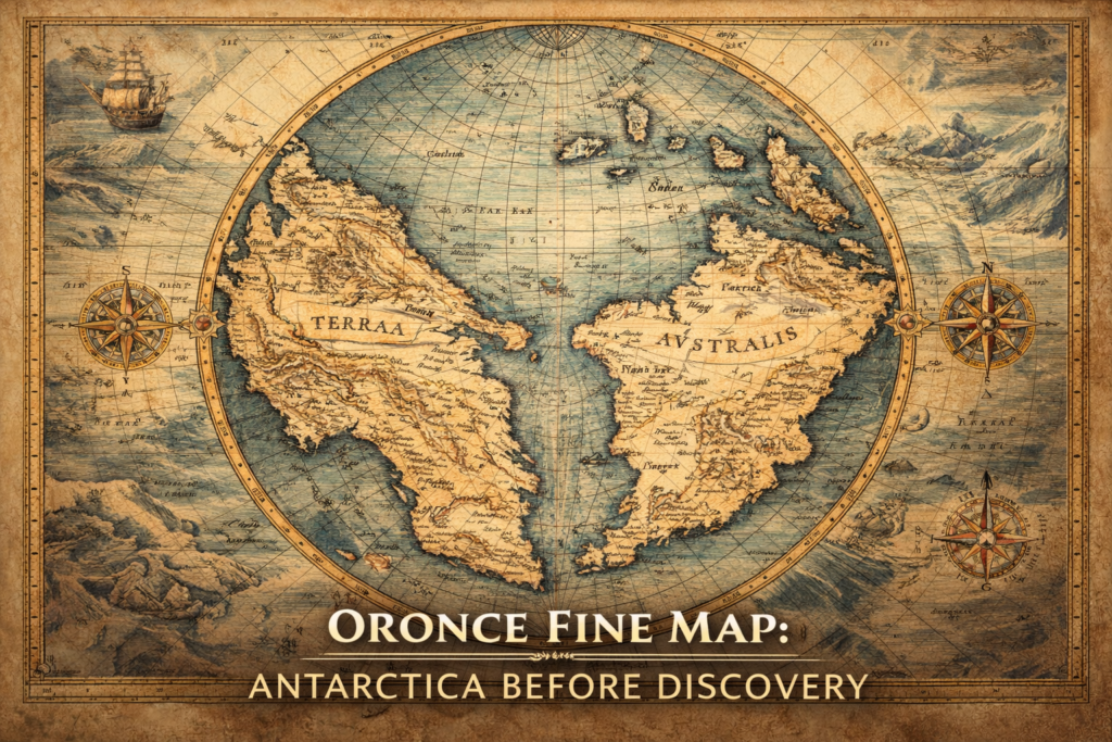
The Oronce Fine Map represents one of the earliest and most controversial depictions of a southern polar continent, portraying a massive landmass in the Antarctic region nearly three centuries before the official discovery of Antarctica, and raising profound questions about the sources of early geographic knowledge and the intellectual frameworks through which Renaissance scholars attempted to reconstruct the structure of the Earth.
Created in 1531 by French mathematician and cartographer Oronce Fine, the map depicts a vast and highly structured southern continent labeled Terra Australis, presented not as a speculative abstraction but as a coherent geographic body with defined coastlines, rivers, and continental features, suggesting an advanced conceptual understanding of global geography at a time when most of the world remained unexplored.
Within the broader history of cartography, the Oronce Fine Map occupies a pivotal position between medieval geographic traditions and modern scientific mapping, representing a synthesis of inherited classical knowledge, mathematical reasoning, and emerging observational data that together produced one of the most enduring geographic enigmas of the Renaissance.
Who Was Oronce Fine? — Renaissance Scientist and Cartographic Pioneer
Understanding the significance of the Oronce Fine Map requires examining the intellectual trajectory of its creator, whose work reflects the scientific ambitions of the early modern period and the expanding European effort to comprehend the global structure of the planet.
Oronce Fine (1494–1555) was a French mathematician, astronomer, and royal cartographer who served as the first professor of mathematics at the Collège Royal in Paris, later known as the Collège de France, where he contributed significantly to the development of geography, astronomy, and instrument design.
His work extended across multiple disciplines, including mathematical instruments, sundials, astronomical observations, and geographic projections, reflecting the Renaissance ideal of integrated scientific inquiry in which mathematics served as the universal language for understanding nature.
Fine’s cartographic efforts were guided by the belief that Earth’s structure could be reconstructed through geometric principles and classical sources, leading him to synthesize ancient texts, traveler reports, and mathematical reasoning into comprehensive global maps.
This interdisciplinary approach allowed him to produce representations that extended beyond direct observation, attempting to reveal the hidden order of the planet through rational reconstruction.
The 1531 Map — A Vision of Terra Australis
The Oronce Fine Map, formally titled Nova Universi Orbis Descriptio, presents a striking representation of the world in which the southern hemisphere is dominated by an enormous continental mass encircling the South Pole.
This landmass, identified as Terra Australis, appears with detailed coastlines, bays, and internal geographic structure, suggesting not merely a theoretical possibility but a fully formed continental system integrated into the global balance of Earth.
The concept of Terra Australis originated in classical geography, particularly the idea that a large southern landmass must exist to balance the continents of the Northern Hemisphere, thereby preserving planetary symmetry.
Fine adopted and elaborated this concept, transforming it into a detailed cartographic representation that extended across the southern latitudes.
Distinctive Features of the Oronce Fine Map
A Fully Formed Southern Continent
Unlike earlier speculative maps that suggested only the possibility of unknown southern lands, the Oronce Fine Map presents a continuous and structured continental mass with recognizable geographic features, including peninsulas, mountain ranges, and river systems.
The level of detail suggests an attempt to portray a realistic geographic environment rather than an abstract theoretical placeholder.
Geometric Projection and Mathematical Precision
Fine’s map employs a cordiform, or heart-shaped, projection that reflects Renaissance efforts to apply mathematical principles to geographic representation, demonstrating the integration of geometry and cosmology in early modern science.
This projection allowed Fine to present the Earth as a unified system governed by measurable relationships between land, sea, and celestial structure.
Integration of Classical and Contemporary Knowledge
The map synthesizes information from ancient geographic traditions, medieval exploration accounts, and emerging Renaissance science, illustrating the transmission of knowledge across centuries and cultures.
This synthesis reflects the Renaissance conviction that ancient wisdom and modern observation together could reveal the true structure of the world.
How the Oronce Fine Map Became Famous
The Oronce Fine Map gained renewed attention centuries after its creation, particularly during the twentieth century when historians of cartography began reassessing early maps in light of modern geographic knowledge.
Researchers observed that the southern continent depicted by Fine bears conceptual similarities to Antarctica’s overall position and structure, leading to discussions regarding whether Renaissance cartographers possessed access to earlier geographic sources or relied purely on theoretical reasoning.
The map’s fame also derives from its role in broader debates concerning the transmission of ancient knowledge, early navigation capabilities, and the possibility that fragments of geographic information survived from earlier civilizations and were incorporated into Renaissance scholarship.
Regardless of interpretation, the map represents a milestone in humanity’s attempt to understand the planet as a coherent physical system.
Renaissance Cosmology and Global Balance
The Oronce Fine Map reflects the intellectual climate of the Renaissance, during which scholars sought to reconcile classical philosophy with empirical observation, constructing models of the Earth that emphasized balance, symmetry, and structural harmony.
The assumption of a southern continent was not arbitrary but emerged from philosophical and scientific reasoning regarding planetary equilibrium, climate distribution, and geometric symmetry.
Within this framework, Terra Australis functioned as a necessary component of the global system, ensuring that Earth’s structure conformed to universal principles of balance.
Interpretations and Ongoing Questions
The Oronce Fine Map continues to inspire debate among historians, geographers, and researchers exploring the origins of scientific knowledge.
Some scholars interpret the map as a testament to the power of mathematical reasoning and theoretical modeling, demonstrating how early scientists attempted to reconstruct unknown regions through logical inference.
Others consider the map’s detailed southern continent suggestive of earlier geographic traditions whose sources remain uncertain, raising questions regarding the transmission of knowledge across historical epochs.
These differing interpretations illustrate the complexity of scientific progress, in which observation, theory, and inherited tradition often interact in unexpected ways.
The Map’s Legacy in the History of Cartography
The Oronce Fine Map represents a transitional moment in the history of geographic thought, bridging the gap between symbolic medieval representations and the empirical mapping practices that would emerge during the Age of Exploration.
Its influence extended beyond its immediate historical context, shaping subsequent representations of the southern hemisphere and reinforcing the idea that unknown regions could be reconstructed through rational analysis.
The map demonstrates how early cartographers sought to understand the Earth not merely as a collection of territories but as an integrated planetary system governed by universal laws.
Conclusion: A Window into Early Scientific Imagination
The Oronce Fine Map stands as one of the most remarkable artifacts of Renaissance science, embodying humanity’s enduring attempt to comprehend the structure of the world long before direct exploration revealed its full geography.
Whether interpreted as theoretical reconstruction, inherited knowledge, or a combination of both, the map reflects the intellectual ambition of an era that sought to unify mathematics, astronomy, and geography into a coherent vision of the planet.
Within the Ancient360 investigation series, the Oronce Fine Map invites readers to reconsider the origins of geographic knowledge and the processes through which humanity has sought to map the unknown, revealing that the history of discovery often begins not with observation but with imagination guided by reason.
Sources and Research References
-
Fine, O. (1531). Nova Universi Orbis Descriptio — original world map (link)
-
Renaissance cartographic archives and early geographic treatises.
-
European library collections of early modern maps (link)
-
Brotton, J. — A History of the World in Twelve Maps (link)
-
Harley, J. B. & Woodward, D. — The History of Cartography (link)
-
Whitfield, P. — The Image of the World: 20 Centuries of World Maps.
-
Edson, E. — The World Map 1300–1492.
-
Studies on Terra Australis theory in Renaissance geography.
Related Ancient360 Internal Resources
-
Ancient360 — Antarctica Mapping Before Discovery (link)
-
Ancient360 — Ancient Navigation Technology (link)
-
Ancient360 — Buache Map Antarctica Investigation (link)
-
Ancient360 — Lost Earth Geography Series (link)