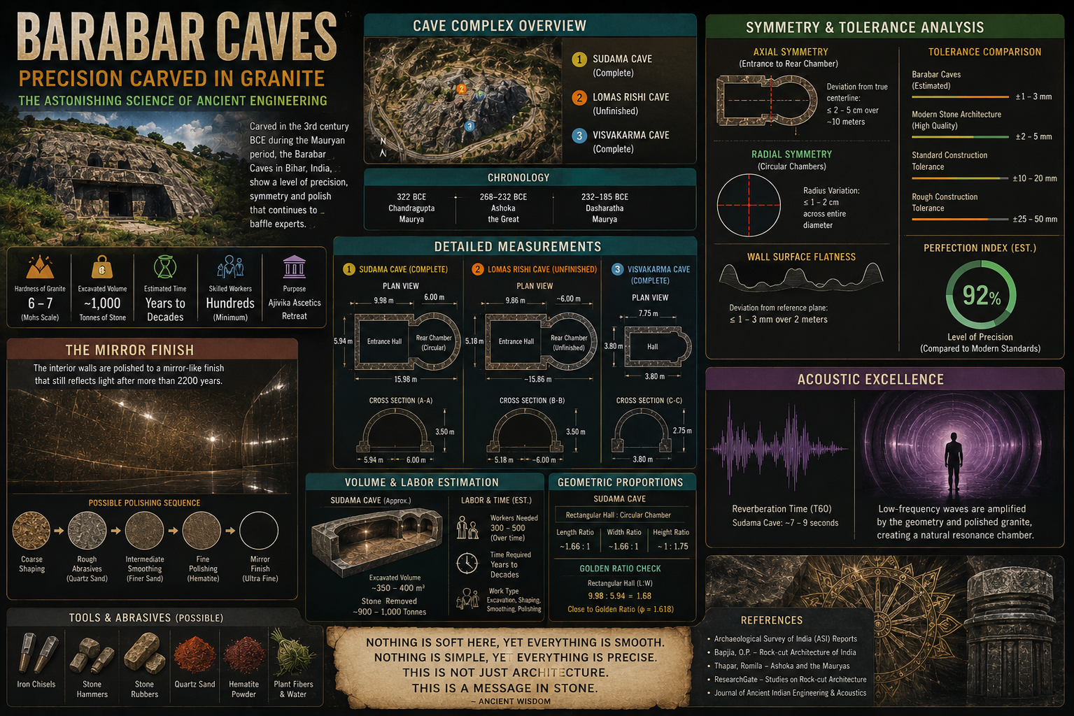
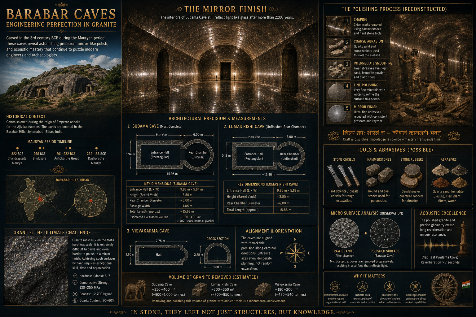
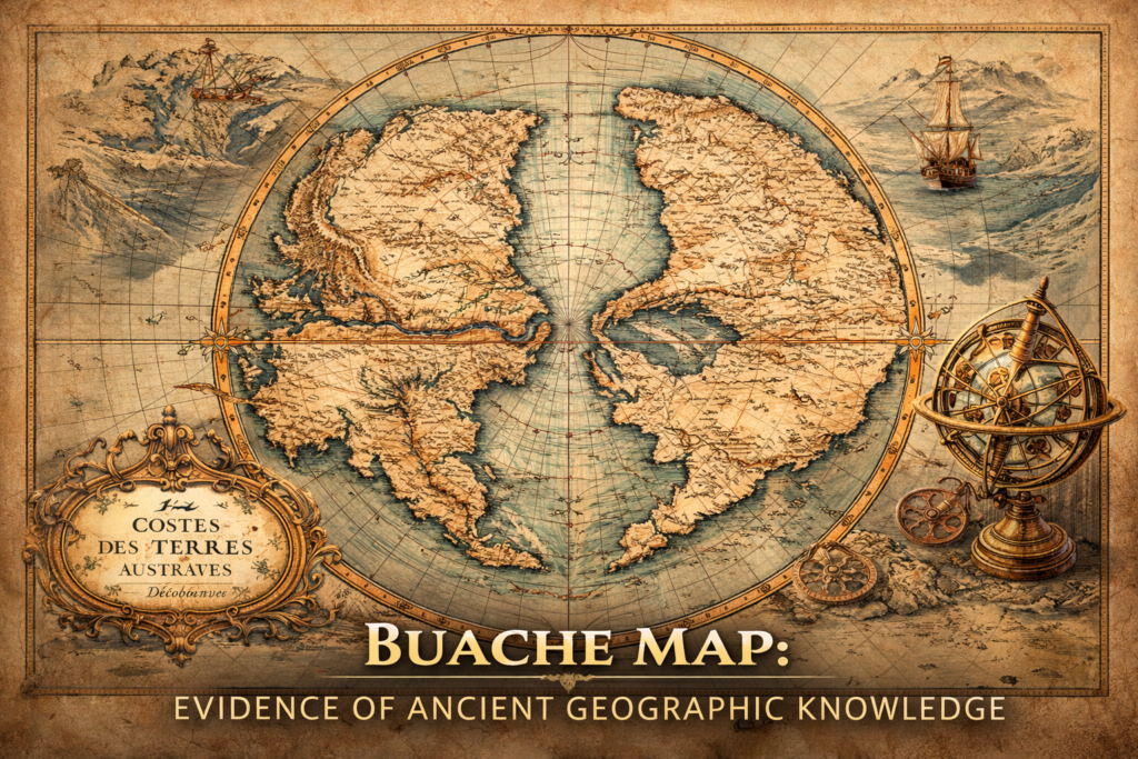
The Buache Map of Ancinet Antarctica represents one of the most perplexing documents in the history of cartography, presenting a detailed representation of the Antarctic continent decades before its official discovery and suggesting an advanced understanding of polar geography that continues to provoke debate regarding the origins of early geographic knowledge and the possibility of lost sources of scientific exploration.
Published in 1739 by French geographer Philippe Buache, the map depicts Antarctica not as an undefined frozen mass but as a structured land divided into two principal bodies separated by an inland sea—an arrangement that some later observers considered strikingly consistent with modern reconstructions of the continent beneath its ice sheets, thereby raising profound questions regarding how such geographic assumptions emerged within eighteenth-century scientific circles.
Who Was Philippe Buache? — Architect of Theoretical Geography
To understand the significance of the Buache Map Antarctica, it is essential to examine the intellectual background of its creator, whose career unfolded at the intersection of empirical observation and theoretical speculation during a period when European science sought to systematize knowledge of the Earth.
Philippe Buache (1700–1773) was a prominent French geographer and cartographer who served as Premier Géographe du Roi (First Geographer to the King of France), and whose work was deeply influenced by the scientific traditions of the Enlightenment, particularly the emerging effort to understand the planet as an integrated physical system governed by coherent structural principles rather than isolated geographic phenomena.
Buache pioneered what became known as theoretical geography, an approach in which the structure of unknown regions could be inferred from global patterns such as river basins, mountain chains, and oceanic circulation, leading him to propose continental forms and geological relationships based on mathematical and hydrological reasoning rather than direct exploration.
His membership in the French Academy of Sciences placed him within one of Europe’s most influential scientific institutions, granting his hypotheses considerable intellectual authority and ensuring that his speculative reconstructions of unknown territories would be treated as serious scientific contributions rather than imaginative curiosities.
The Map’s Origins — From Hypothesis to Cartographic Representation
The Buache Map Antarctica emerged from attempts to resolve one of the central geographic questions of the eighteenth century: whether a massive southern continent existed to balance the landmasses of the Northern Hemisphere, a concept inherited from ancient Greek geography and widely accepted by European scholars.
Drawing upon reports from early explorers, oceanographic observations, and geometric reasoning regarding Earth’s structure, Buache constructed a vision of the southern polar region that extended beyond known coastlines and ventured into the realm of predictive cartography, proposing the existence of a continental system structured by internal waterways and mountain ranges.
His map, titled Carte des Terres Australes, portrayed the southern continent as two major landmasses separated by a navigable sea that penetrated deep into the interior, surrounded by elaborate coastlines and river systems, suggesting not merely a speculative outline but a fully organized geographic environment governed by hydrological logic.
The publication of the map generated significant interest because it transformed an unknown region into a coherent geographic system, presenting Antarctica not as a theoretical possibility but as a structured landscape with measurable features.
Buache Map Antarctica and Its Unusual Features
Several characteristics distinguish the Buache Map Antarctica from other early representations of the southern hemisphere, contributing to its lasting historical fascination.
A Divided Antarctic Continent
The most striking feature of the map is the depiction of Antarctica as two separate continental masses divided by an inland sea, a concept that appears unexpectedly sophisticated given the absence of direct observation of the region at the time.
Modern surveys of the subglacial topography of Antarctica have revealed that the continent contains vast basins and geological separations beneath its ice sheets, including the West Antarctic Rift System, which creates a structural division between eastern and western regions—an observation that later commentators viewed as a remarkable parallel to Buache’s theoretical reconstruction.
Hydrological Logic and River Systems
Buache applied hydrological reasoning to unknown territories, proposing that continental interiors must contain drainage basins and river networks consistent with global geographic patterns, and therefore constructed Antarctica as a land shaped by flowing water rather than an inert mass of ice.
This approach reflected Enlightenment confidence in universal natural laws and reinforced the idea that Earth’s surface followed predictable structural principles that could be deduced through rational analysis.
Mountain Ranges and Continental Structure
The map also includes mountain chains and interior relief features that organize the continent into distinct geographic zones, suggesting a dynamic landscape shaped by geological processes rather than a static frozen environment.
Such structural organization reinforced Buache’s broader theory that continents and oceans formed interconnected systems governed by underlying physical laws.
How the Map Became Famous
The enduring fame of the Buache Map Antarctica arises not from its immediate impact in the eighteenth century but from its later reinterpretation in the context of modern scientific discoveries and alternative perspectives on ancient knowledge.
During the twentieth century, renewed interest in historical cartography led researchers and independent scholars to revisit early maps of unknown regions, comparing them with contemporary geographic data and identifying apparent correspondences that seemed difficult to explain within conventional historical frameworks.
The Buache map gained prominence because of its apparent anticipation of Antarctica’s divided structure and its detailed internal geography, which some interpreters considered evidence of earlier sources of information, potentially derived from lost exploratory traditions or inherited geographic knowledge.
Regardless of interpretation, the map remains a compelling example of how theoretical reasoning can produce representations that appear to anticipate later discoveries.
Scientific Context — Enlightenment Geophysics and Global Balance
Buache’s work must be understood within the intellectual climate of Enlightenment science, which sought to explain Earth as a balanced physical system governed by measurable principles, including the distribution of landmasses, ocean currents, and atmospheric forces.
The hypothesis of a southern continent served to explain climatic symmetry and planetary equilibrium, leading geographers to assume that unknown regions must conform to structural patterns observed elsewhere.
In this sense, the Buache Map Antarctica reflects the transition from mythic geography to scientific modeling, representing an early attempt to predict Earth’s structure through systematic reasoning rather than direct exploration.
Interpretations and Ongoing Debate
The Buache Map Antarctica continues to generate discussion among historians of science, geographers, and researchers exploring the history of knowledge transmission, with interpretations ranging from rational scientific speculation to evidence of forgotten geographic information.
Some scholars view the map as a remarkable example of Enlightenment predictive reasoning, demonstrating the power of theoretical models to approximate unknown realities, while others interpret its apparent accuracy as suggestive of earlier sources of geographic knowledge that remain poorly understood.
What remains indisputable is that the map challenges simplistic narratives of discovery by illustrating that knowledge of Earth’s structure has often evolved through complex interactions between observation, inference, and intellectual tradition.
Conclusion — A Cartographic Enigma of Human Knowledge
The Buache Map Antarctica stands as one of the most fascinating documents in the history of cartography, representing a moment when scientific imagination, theoretical reasoning, and geographic speculation converged to produce a vision of the southern continent that continues to inspire investigation and debate.
Whether interpreted as a triumph of Enlightenment science or as a fragment of deeper geographic memory, the map reveals the enduring human impulse to understand the structure of the planet long before direct exploration made such knowledge possible.
Within the broader Ancient360 framework, the Buache Map Antarctica invites a reconsideration of how knowledge emerges, evolves, and persists across generations, reminding us that the boundaries between discovery and inference are often more complex than conventional history suggests.
The Buache map continues to generate debate because it occupies the boundary between scientific speculation and historical anomaly, forcing researchers to reconsider the processes through which geographic knowledge is created, preserved, and transmitted across time.
Additional reading and source
-
Philippe Buache publications – link
-
Antarctic geological surveys – link
-
History of cartography research journals – link
Research & Analysis
-
Maps of the Ancient Sea Kings — Charles Hapgood – link
-
Royal Geographical Society research archives – link
-
Academic cartography studies on early map projections
-
Megalithic engineering tolerances article – link
-
Great Pyramid erosion investigation – link
-
Polynesian navigation studies — anthropological research – link