The Sources and Historical Context of the Philippe Buache Map
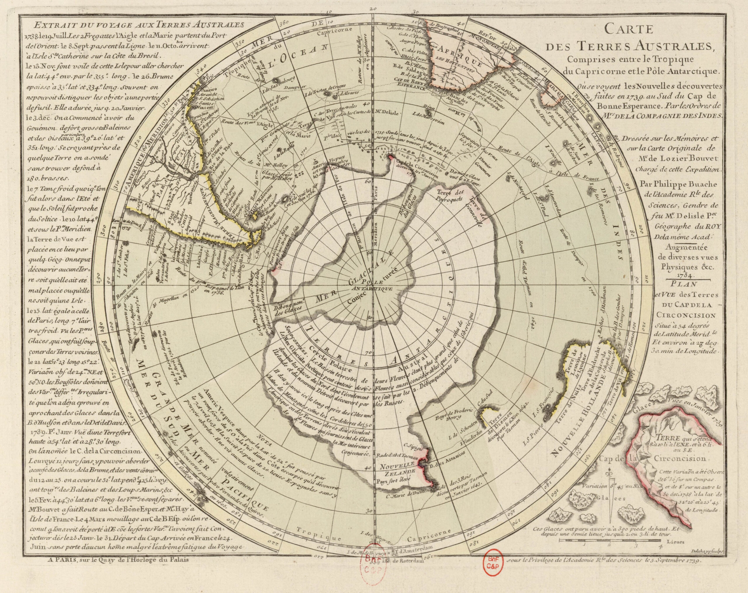
The Philippe Buache map represents one of the most debated artifacts in the history of cartography, presenting a depiction of Antarctica that appears to include structural geographic features long before the continent was officially discovered in the nineteenth century, thereby raising fundamental questions regarding the origins of geographic knowledge and the transmission of scientific information across centuries. Produced in the eighteenth century by Philippe Buache, one of the most respected geographers of Enlightenment Europe, the map illustrates a southern continent divided into separate landmasses by internal waterways, a configuration that some researchers argue resembles the subglacial structure of Antarctica revealed only through modern radar surveys.
Understanding the significance of this map requires examining not only its visual features but also the intellectual environment in which it was produced, the scientific reputation of its creator, the sources upon which he relied, and the historical processes through which geographic knowledge was preserved, transmitted, and sometimes lost. The broader context includes centuries of cartographic tradition involving scholars such as Gerardus Mercator and Oronce Fine, whose maps depicted the hypothetical southern continent known as Terra Australis long before Antarctica entered modern geographic awareness.
The persistence of such representations across multiple generations of mapmakers raises a central question: were these depictions theoretical constructions rooted in philosophical speculation, or did they preserve fragments of geographic knowledge inherited from earlier civilizations whose records were partially lost through catastrophic events, cultural collapse, or the destruction of ancient repositories of knowledge such as the Library of Alexandria?
Who Was Philippe Buache — The Scientist Behind the Map
Philippe Buache was not an obscure or speculative thinker but one of the leading geographers of eighteenth-century France, appointed as Premier Géographe du Roi (First Geographer to the King) and a member of the prestigious French Academy of Sciences. His work was characterized by a systematic approach to geography that integrated hydrography, geology, and physical geography into a unified scientific framework, reflecting the Enlightenment ambition to understand Earth as an interconnected system governed by natural laws.
Buache was particularly influential for developing the concept of theoretical geography, which sought to reconstruct unknown regions of the Earth through scientific reasoning based on known physical principles such as mountain formation, ocean basins, and watershed distribution. Rather than simply recording observations from explorers, he attempted to predict geographic structures through analysis of environmental patterns, thereby positioning his work at the intersection of empirical observation and scientific modeling.
This methodological approach is essential to understanding the Philippe Buache map, because it reflects both scientific inference and reliance upon earlier geographic traditions, suggesting that his depiction of Antarctica may represent a synthesis of inherited knowledge and theoretical reconstruction rather than pure speculation.
The Creation and Discovery of the Philippe Buache Map
The map commonly associated with Philippe Buache emerged from his 1739 presentation to the French Academy of Sciences, where he proposed a revolutionary model of the southern polar regions based on available geographic data and theoretical analysis. Unlike earlier representations of a single massive southern continent, Buache depicted Antarctica as composed of separate landmasses divided by internal seas, a concept that appeared highly unconventional for its time.
The map gained attention in later centuries when researchers noted that modern surveys of Antarctica revealed a subglacial landscape consisting of distinct geological regions separated by deep basins, leading some commentators to suggest that Buache’s model resembled features that were not scientifically confirmed until the twentieth century through seismic and radar mapping technologies.
The rediscovery of Buache’s work by modern historians of cartography and alternative researchers contributed to renewed debate regarding the origins of his geographic knowledge and the sources from which he derived his information.
Distinctive Features of the Philippe Buache Map
The most remarkable aspect of the Philippe Buache map is its depiction of Antarctica as a divided landmass, separated by waterways that suggest an internal ocean or channel system beneath the ice. This representation differs significantly from earlier cartographic traditions that portrayed Terra Australis as a single continuous continent, indicating that Buache’s work introduced a novel conceptual framework for understanding the southern hemisphere.
Additional features of the map include carefully structured coastlines, detailed geographic segmentation, and a systematic representation of global oceanic circulation patterns, reflecting Buache’s broader interest in the relationship between terrestrial geography and marine dynamics. The level of structural organization present in the map has led some researchers to argue that it reflects access to geographic information that exceeded the exploratory capabilities of the eighteenth century.
While mainstream scholarship interprets these features as theoretical constructs derived from Enlightenment scientific reasoning, critics contend that the specificity of certain geographic elements raises questions about whether Buache relied upon earlier source material now lost to history.
Scientific Interpretation vs. Historical Anomaly
Conventional historians of cartography maintain that Buache’s depiction of Antarctica resulted from theoretical reasoning rather than empirical observation, emphasizing that Enlightenment scholars often extrapolated geographic features based on limited data. From this perspective, the resemblance between Buache’s map and modern Antarctic geography is attributed to coincidence or interpretative projection.
However, alternative interpretations emphasize the possibility that Renaissance and early modern mapmakers preserved fragments of geographic knowledge inherited from ancient civilizations, potentially transmitted through maritime traditions or preserved in lost archives. This perspective aligns with broader hypotheses concerning advanced prehistoric navigation capabilities and the cyclical rise and decline of human technological achievement.
The debate surrounding the philippe buache map therefore reflects a deeper tension between linear models of historical progress and cyclical models of knowledge development, in which civilizations may achieve sophisticated understanding only to lose it through environmental catastrophe or cultural collapse.
Implications for the History of Geographic Knowledge
If the philippe buache map reflects inherited geographic knowledge rather than theoretical speculation, its implications would extend far beyond cartographic history, challenging established assumptions about the development of navigation, exploration, and scientific understanding. It would suggest that earlier civilizations may have possessed capabilities in surveying, mapping, and global exploration that exceed those traditionally attributed to them.
Such a possibility invites reconsideration of historical events that resulted in the loss of knowledge, including climatic disruptions such as the Younger Dryas period, the destruction of major libraries, and the collapse of complex societies, all of which may have contributed to the fragmentation of earlier scientific traditions.
Conclusion — A Map That Continues to Challenge History
The philippe buache map remains one of the most compelling artifacts in the study of ancient cartography, occupying a unique position at the intersection of scientific reasoning, inherited tradition, and historical mystery. Whether interpreted as a product of Enlightenment theoretical geography or as evidence of lost knowledge transmitted across generations, the map challenges researchers to reconsider the complexity of human intellectual history and the possibility that fragments of ancient understanding persist within the historical record.
Its enduring significance lies not merely in its depiction of a southern continent but in the broader questions it raises about the origins of knowledge, the transmission of scientific insight, and the potential existence of forgotten chapters in humanity’s past.
Additional Reading and References
-
French Academy of Sciences archives — Philippe Buache papers (link)
-
Library of Congress Map Collections (link)
-
British Library Cartographic Archives (link)
-
Charles Hapgood — Maps of the Ancient Sea Kings (link)
-
J.B. Harley & David Woodward — The History of Cartography
-
National Snow and Ice Data Center — Antarctic geology research
-
Terra Australis Hypothesis (link)
-
Ancient Maps Series — Oronce Fine Map (link)
-
Ancient Maps Series — Mercator Antarctica Map
-
Ancient Maps Series — Bauche Map Ancient Antartica (link)
- Ancient Maps (link)